Chapter 3: Gaillimh to Eanach Dúin (Annaghdown)
- Terrilan Castle
- Menlo Castle
- Claregalway
- Creag Castle
- Hags Castle
Return to table of contents
Refer to Map
On the west,
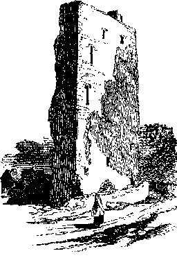
as the eye traverses this apparently sterile region, it rests on the chimney
of the lead mine at Gort Mór, and the grey side-wall of Tulach Cadhain
Castle popularly called Caisleán na Caillighe, or the Hag's Castle of which
the accompanying illustration, from a drawing made by Mr. Wakeman gives a
good idea. This castle is called Tullokyne on the Ordnance Map, and it must
not be confounded with Caisleán na Caillighe on Loch Measca, referred to in
the Donegal Annals under A.D. 1195. In 1586, Muriertach O Conor held the
castle of Tullekyhan. Of its origin, or true history, we know nothing but it
is mentioned by O Flaherty in 1684, when a similar structure, a few paces
distant, existed, which was blown down by the great storm of January, 1839.
They were called, says Hardiman, "the Castles of the two Sisters, of whom
some romantic tales of former days are still current."
 Among these, the
people state that when these old maids were too old to visit, they built
these castles in such close contiguity in order that they might daily
"barge" one another from their respective windows. At long run, however, the
dame that owned the present ruin cut short the dispute by killing her sister!
Among these, the
people state that when these old maids were too old to visit, they built
these castles in such close contiguity in order that they might daily
"barge" one another from their respective windows. At long run, however, the
dame that owned the present ruin cut short the dispute by killing her sister!