Chapter 3: Gaillimh to Eanach Dúin (Annaghdown)
- Terrilan Castle
- Menlo Castle
- Claregalway
- Creag Castle
- Hags Castle
Return to table of contents
Refer to Map
So far on our course we have passed through the barony as well as the county of Galway--between the parishes of Rahún on the left and St. Nicholas on the right; and in the latter, besides that of Tír Oileáin, already described, we have the ruins of Caisleán Gearr, Baile Briota and Merlin Castles; but they are not of sufficient importance nor vicinity to the lake to merit detailed description, or require illustration.
The large parish of Órán Mór, through a portion of which we passed on approaching Galway, and which contains the castle and townland of Mionloch, here runs down to the lake margin between those of St. Nicholas and Claregalway; but its early inhabitants seem to have concentrated their energies more upon its sea-board than its lacustrine border, and have left us nothing worthy of attention at this end of it, except the ruins of the square Castle of Cluain a' Cháinín and that of Ceathrú Bhrúna.
Here, as we pass upwards, the Coirib River diverges to the west; and, we enter, through a deep sedgy marsh or bog, about a mile in length, the canal traditionally called the "Friars' Cut," and emerge into the broad waters of the Lower Lake. On the left, or western side of our course, may be seen the ridge of hills that stretches from Gaillimh to Uachtar Ard; and along their slopes the demesnes of Woodstock, Farm, Danesfield; and also the village of Magh Cuilinn, as we proceed, the woods of Druim Cunga, Cnoc Bán, and Ros.
As we pass into the broad uninterrupted space of lower lake, we have on our right the marble quarries Angliham, and soon get a glimpse over the low limestone plain, eastward of our course, of the butt of the old castle, and the tall slender tower that rises from the centre of the Friary or cruciform church of Baile Chláir na Gaillimhe, Claregalway, which, although at some distance from the water's edge, is not without our prescribed parochial limits, and is of too great beauty and importance to be omitted; and, moreover, it is on the highroad between Galway and Cong, being but six miles distance from the former. A more picturesque group of ruins, or one comprising a greater variety for the display of the artist's pencil, can scarcely be found, even amidst the multitudinous remains that crowd the parishes abutting upon Loch Coirib, than this scene presented in former days--with its little mill, and slow winding river passing under a long, low, many-arched bridge, but which is now replaced by a canal, and a single formal arch.
The massive square ivy-clad keep of the castle, now used as a barn, stands
on the east of the roadside, and was formerly the residence of Mac Uilliam
Uachtar De Burgo, as stated by the Four Masters, under the date 1469, in
which year it was burned by Aodh Rua O'Domhnaill. As it was contiguous to
the famous battlefield of Cnoc na dTuagh, fought between the Earls of
Kildare and Clanricarde in 1504, it was occupied by the Irish party; and in
1512 it was again the seat of war. It is at present
The records state that about the year 1290, John De Cogan built a Monastery at Clare-yn-dowl for Franciscan Friars, in a very elegant style, and at great expense.
Although the modern name of this parish is Claregalway, it is called in Irish Baile an Cháir, the town of the Clár or "flat"--a title which it well deserves. There are several Clares and Bally-Clares in Connacht--and it requires some topographical knowledge to distinguish which is the one referred to in the annals and histories; but this locality is styled, in ancient documents "Clár an Diabhail," or "Devil's Flat," or board, because, according to tradition, the rapid river at this place was formerly crossed on planks supported on pillars.
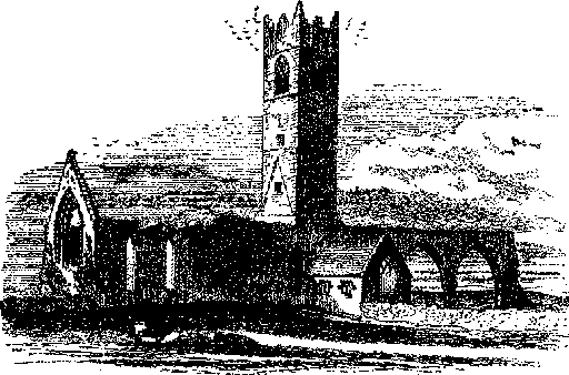
The ruins of the Friary or Convent Church stand on the right or northern bank of the river, a little below the Castle; and, like most other structures which came from the hands of the Franciscans, it is characterized by a taste and elegance which neither time, nor the rough hand of the despoiler has been able to efface. It was originally cruciform; and from the intersection of the nave, choir, and transepts, was reared, on high pointed arches, a tall slender tower.
The illustration has been taken from the south-east, and represents, besides the tower, the dilapidated east window, the northern arches of the nave, and the small chapel, in which the friars had service up to 1860. The entire length of this church was one hundred and forty-two feet, and that of the transept, one hundred and twelve.
The height of the tower is about
There are not now many tombs of note within the precincts of this venerable
and still beautiful pile; but among the well-cut flagstones paving the
aisles of nave and transept, may be seen early indications of the
agricultural skill of the people of this great fertile plain or Clár, in the
number and variety of ploughs carved
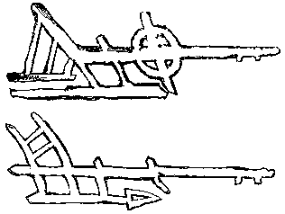 upon them.
They bear date from the middle of the seventeenth to the end of the
eighteenth centuries; and the two preceding fac-simile cuts, selected out of
eight represent that early civilizer as it existed in Galway, the upper one
in 1696, and the lower in 1773. Upon the left or southern bank of the river
stands a large ecclesiastical ruin, surrounded by a graveyard.
upon them.
They bear date from the middle of the seventeenth to the end of the
eighteenth centuries; and the two preceding fac-simile cuts, selected out of
eight represent that early civilizer as it existed in Galway, the upper one
in 1696, and the lower in 1773. Upon the left or southern bank of the river
stands a large ecclesiastical ruin, surrounded by a graveyard.
About