|
Chapter 2: Description of Loch Coirib
Return to table of contents
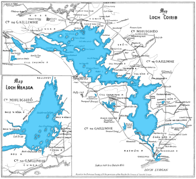
Refer to Map
|
Loch Corrib, which is the
second largest sheet of inland frest water
in Ireland, is about
thirty-five miles
in length from Galway to
MŠm
and varies in breadth from eight
miles, as between
Oughterard and
Cong, to
one quater of a
mile, as from the
Wood of Dķn to
CorrŠn Point, where it narrows between the
Joyce Country and the
Iar-Chonnacht hills. Its general direction is from west-north-west, in
a curvature, to south-south-east. In depth it varies considerable. It
is in many parts full of rocky shoals, dry in summer; and, even in the
navigation course, having but
six
or
seven feet
of water in some
places. In other parts it descends to
one hundred and fifty-two feet,
as between the island of
Inis mhic a' trŪr and
Cong, and between
Dubhros Island
and Fornocht Point, which portions are styled by the
fishermen "The Old Loch." The
accompanying map, to a scale of half an
inch to the statute mile, taken from the Admiralty Chart made in 1846,
and the Ordnance Survey Maps, shows the principal islands, the
navigation course, the rivers, and the chief objects of interest along
its shores.
At the commencement of its tortuous course among the mountains, Loch
Coirib has the county of Galway on both sides, along the baronies of
Ross and
Moycullen.
At the north-east, it divides the counties of Mayo
and Galway, along the south margin of the barony of Kilmaine
in the
former, from the river of Cong to the
Black-river of Shrule, about a
mile
to the north of the ruins of
Eanach Caoin Castle, on the east
shore. From thence southwards, during the remainder of its course, it
has the county of Galway on both sides -- the barony of Clare
on the
east, and that of Moycullen
on the west; but the river between the
south end of the lake and the sea passes through the
Barony of Galway.
The old Irish name of this sheet of water was Loch Oirbsein or Orib, now
corrupted into Coirib, and derived from the ancient Danann navigator, Orbsen
Mac Alloid, commonly called ManannŠn Mac Lir, "The Son of the Sea," from
whom the Isle of Man is designated.
He was slain in conflict by Uillin, grandson of
Nuadu of the Silver Hand, King of Tuatha Dť
Danann, in a battle on the western margin of the lake; and from that
circumstance this district is called Magh-Uillin, the plain or field of
Uillin or Magh Cuilinn [Moycullen], and O'Flaherty says that in his day
a great stone thereon, six
miles from Galway, marked the scene; it still exists.
The ancient territories along it were Iar-Chonnacht, comprising
Gnů Mor and Gnů Beag -- with Conmaicne-Mara,
now Conamara, on the west, and UŪ Briķin Seůla on the east border, and
towards the north-west Dķtha Seůigheach, the Joyce Country, between it and
Lough Mask;
and more to the north-east, Conmaicne
Cķile Tola, the barony of Kilmaine,
where the first great battle of
Moytura was fought.
Loch Coirib covers a space of
forty-four thousand acres
and its
watershed in the counties of Mayo and Galway comprises an area of
seven
hundred and eighty thousand acres. The summer level of the lake is
fourteen feet
above the medium data of the sea in Galway Bay, and
thirty seven feet
below the surface of Lough Mask.
This sheet of water formerly
extended over a much larger space; but by the drainage
operations carried
on from 1846 to 1850 it was lowered, much valuable land relieved from
flooding, and large tracts rendered capable of
cultivation; and I myself remember passing in a boat over places now in good
pasturage, and fishing in places at present occupied by flourishing
plantations.
Its chief
western supply is from the great catchment basin of the Valley of MŠm
[geog1],
stretching westwards towards the salt water fiord of the Killeries, and
affording the vast supply of water from the sea clouds caught on the
Joyce
Country and
Conamara Mountains, and pouring it down through the River
BťalŠnabreac, 'the mouth of the ford of the trout ' --
(the largest stream
in Ireland for its length and its tributary the Faill Můr,
into the lake
at Bun BonŠin, near MŠm, where they coalesce.
|