Chapter 10: An Mám to Gaillimh
- chapter 10
Return to table of contents
Refer to Map
THERE IS COMPARATIVELY LITTLE OF interest on the southem shores of the upper and middle lake, except wild mountain scenery, and no object worth stopping for, from Mam to Uachtar Árd. Brown bogs, bare mountains, a succession of small lakes, some turf clamps, and a few cottages, are all that are here.
As we approach Uachtar Árd, some evidences of civilization appear. Claremont, formerly called "Dick Martin's Gatehouse," is on our right- and beside it the pretty fall of the Fuathach, or Abhainn Ruibhe, "the sulphur river," carries down the surplus waters of the great catchment basin to the east of the sumrnit level of the road into Conamara. We pass along its picturesque margin, studded with trees, and overhung by ledges of dhe natural rock, by the pretty residence of the Catholic clergyman, formerly occupied by Dean Kirwan, and by the usual public buildings of a small provincial town, into Uachtar Árd, or "the upper height," a pretty little town in the parish of Cill Cuimín. There are very comfortable hotels at Uachtar Árd; and from this point, as well as from Cunga, on the opposite shore, several of the most interesting localities on Loch Coirib can be visited with facility. There is also admirable fishing in the neighbourhood.
Among the objects of interest may be enumerated a series of remarkable subterranean chambers in the townland of Creag, for plans of which we are indebted to Mr. Kinahan; also a natural bridge over the Abhainn Ruibhe, at Uachtar Árd, in which stream may still be found fresh water pearl-bearing mussels, and lampreys; the traces of the old Casde of Fuagh, near the military barracks; the curious old church of Cill Cuimín, the burial place of the O Flahertys in later days, a little to the east of the demesne of Lemonfield--and also the church of Port a Ceathrún, near the edge of the lake.
From the Fuathach river at Uachtar Árd to Bail' U1 Chuirc Lake, near Magh Cuilinn, dhe antiquarian tourist may again with great profit resume his explorations either along shore, or by making detours to the north of the Galway road. The south-western shore of the middle and lower lakes, comprising the ancient territories of Gno Mor and Gno Beag, in the barony of Moycullen, and including the parishes of Kilcummin, (part of) Killannin, Moycullen, and Rahoon, stretching between Uachtar Árd and Galway, is a very remarkable region, and one with which, as seen from a distance at least, the tourist passing from Galway into Conamara is not altogether unacquainted. It possesses some special characters, and abounds with objects of interest, both natural and artificial. Its southern and westem boundary is the range of hills that stretch from Galway towards Conamara through the extensive district of Iar Chonnacht, along which the road runs, and its eastern and northern margin is the lake shore. The hills are brown with bog, and dappled with the grey bare rocks that rise towards their summits, or margin the streams that course down their rugged sides, and in autumn are purple with occasional strips of heather, which the continuous waterflow along their sides has permitted to enjoy a partial inflorescence. In the boundary line along which the main road runs, patches of culture--small lakes catching the downfall from the hills--wooded glades, a few villages, and some gentlemen's seats present themselves, and beyond these to the lakc margin all is stony and sterile; and, but that there are still Irish hearts beating upon it, and vestiges of early Christianity existing thereon, it might be styled one of the most inhospitable regions of the globe. Along the lake shore there are entire townlands of grey limestone rock, here stratified, and forming tables of continuous and partially level acres of surface --there disruptured, and appearing like the scattered debris of some ruined building, with stunted hazel bushes interspersed. This great stone crop is here and there interspersed with scraps of " sad-coloured bog "; and, in the neighbourhood of the villages, a few acres of oats and potatoes.
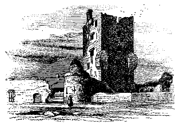
Taking up our itinerary again from Uachtar Árd by the main road to Galway, we pass the site of the holy well of St. Cuimm, who gave his name to this parish; and a little farther on we pass his church, already referred to, and then by the remains of the picturesque ruin of Cill Urumhain church, near the natural bridge over the Druimmn river, that runs down from Buffy Loch, and along by the circle of standing stones on the townland of Leacht Geanainn towards Ros, in the Parish of KillanLin, which here indents that of Kilcummin. From this portion of the road we obtain a view of the tall massive tower of Achadh na nIubhar Castle, which stands to the north by the water's edge, and is by far the finest fortified dwelling upon any part of the shores of Loch Coirib. Turning to the left, north of the main road, and nearer Oughterard than Killeroon, we approach this noble ruin from the west, where there are the remains of extensive outworks; and where probably a drawbridge and portcullis originally existed. The scene here is very picturesque--the Drimneen river passing in several places underground, like its larger brother at Cong, and then forming deep, clear pools among the crags and along the foundations of the castle walls, and, after playing hide and seek with itself, turns from the west by the north face of the castle, where it leaves the waterport, and then winds in slow and easy pace to a deep indentation of Loch Coirib. Along this western face of the ruins, the sketcher will find many points among the broken bushy foreground from which to take away a remembrance of the great stronghold of the once powerful sept of the O Flahertys, the chieftains of the West.
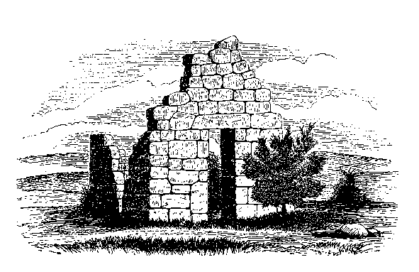
Aughnanure--Achadh na nIubhar, " the field of the yews," is so called from the number of these trees that of old grew all round this spot, and that probably extended for a long distance eastward; so that there is a tradition still alive that the wild cats and tree martins--nay, that man himself could have walked on their tops from here tO Tullokyan without putting foot to ground! To a portion of the remains of this yew wood in an almost fossilized condition, eas~wards of this spot, we shall presently conduct our readers. See page 176. Near the westem entrance of this extensive fortress the last living specimen--probably five hundred vears old- -of this ancient forest still flourishes.
The ground plan of Aughnanure is nearly square, with an offset at
the north-western corner, where the river assists to form a natural
defence. There were circular flanking towers at the eastern corners of
the great enclosure, the entire of which latter measures one hundred
and fifty feet along the interior of the connecting wall, and one
hundred and seventy-eight feet by the southern. At the north-west
corner of the quadrangle stands the great keep, or square tower, of
six stories, over sixty feet high, and measuring forty on the
northern, and twentyeight feet wide on the southern face-- which, with
all its architectural details; the adjoining Round-House; a portion of
the walls of the banqueting hall to the left of the view, and part of
one of the gateways to the right, is most faithfully represented in
the drawing on the next page, taken from the south-east by Mr.
Wakeman. This tower is admirably built, and is likely to last for
centuries yet to come. Within the enclosure, and a short distance from
the south-east angle of the tower, stands the round house, with a
cupola at top, which is reached
by a flight of steps, the roofings of which afford most remarkable
examples of the perfection of that style of beehive doming by
overlapping stones, of which we have so many very early specimens of
Pagan structures
 throughout Ireland, the finest example being that of Newgrange. This
curious structure may have been intended for a magazine; but, being
loopholed in some places, it was also probably used for a citadel.
Nearly parallel with the great tower, and in connection with the
western angle of this round house, there existed some years ago the
remains of another building, twenty-three and a half feet wide, but
this has been for some time removed; and its site is at present
occupied by a modern structure.
throughout Ireland, the finest example being that of Newgrange. This
curious structure may have been intended for a magazine; but, being
loopholed in some places, it was also probably used for a citadel.
Nearly parallel with the great tower, and in connection with the
western angle of this round house, there existed some years ago the
remains of another building, twenty-three and a half feet wide, but
this has been for some time removed; and its site is at present
occupied by a modern structure.
For seventy-six feet along the western face of this enclosure, and
to the south of the keep, stand the remains of the great banqueting
hall, the mullioned windows of which, looking eastward, and gorgeously
sculptured on the round so~lts of their interiors, afford us,
undoubtedly, the finest specimens of floral decorative stone
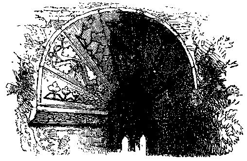 carving of their period in Ireland; and perhaps, if we said in the
British Isles~ our boast might not be susceptible of verified
contradiction. Two of these windows are well worthy of minute
examination; and the top of one of them here displayed gives but a
faint idea of the richness, variety, and delicacy of carving by which
these beauteous arches were characterized. Our ouly wonder is, that in
these days, in which architects have endeavoured to reintroduce forms
and appliances in art quite inapplicable to the present period,
colouring unsuited to our climate, and, with blind subservience to the
necessities of times, countries, habits and tastes long gone by, have
been
labouring to reproduce medievalism in stone, brick, plaster, and
woodwork, as well as in opinion and thought --they have never copied
the graceful decorations of the banqueting hall of Aughnanure.
carving of their period in Ireland; and perhaps, if we said in the
British Isles~ our boast might not be susceptible of verified
contradiction. Two of these windows are well worthy of minute
examination; and the top of one of them here displayed gives but a
faint idea of the richness, variety, and delicacy of carving by which
these beauteous arches were characterized. Our ouly wonder is, that in
these days, in which architects have endeavoured to reintroduce forms
and appliances in art quite inapplicable to the present period,
colouring unsuited to our climate, and, with blind subservience to the
necessities of times, countries, habits and tastes long gone by, have
been
labouring to reproduce medievalism in stone, brick, plaster, and
woodwork, as well as in opinion and thought --they have never copied
the graceful decorations of the banqueting hall of Aughnanure.
The east wall alone of this grand revelling chamber is standing. Under it flowed the Druimmn, covered by a natural arch, which having given way, all the western side was precipitated into the abyss below; where, no doubt, if excavations were made, many of its sculptured stones would be discovered.
The De Burgos claim the erection or re-edification of this castle;
but, besides all other probabilities as to its being originally built
by, as it was undoubtedly occupied by, the O Flahertys in the
sixteenth century--when in all likelihood the bulk of the present
structure was erected --we learn from various sources that the latter
occupied this district uninterruptedly from the eleventh century till
almost the present time. In the records relating to this family will
be found the best account, as well as the last remnant, of the feudal
or clan system in Ireland; when The O Flaherty, besides the various
petty chieftains dependent on him, had his allotted bodyguard,
co-arbs, physicians, equerries, and brehons, as well as his standard
bearer, guardian of reliques, poet, historian, genealogist, master of
the revels, steward, keeper of the bees, and collector of revenues,
etc.; whose names, and the townlands allotted for their services, were
enumerated in the twelfth century. [fn172-1].
One of the last notices of this
fortress
Part of Cill Cuimin parish stretches still further eastwards along the lake shore, which it separates from the parish of Cill Aithnln, until the latter divides it from Magh Cuilinn, near the ferry of Cnoc, already described at page 36. Retracing our steps, and regaining the Galway road, we again proceed eastward by Killeroon church, near which there is a granite boulder with a bulla'n excavated in it; and then by the standing stones of Leacht Geanainn, already referred to, into the parish of CILL AITHNiN, which derives its name from Saint Aithtun V, whose well and church stand by the northern margin of Ross Lake, below the main road. Upon the right of the highway is the small sheet of water called Loch na n-Aoibhinn, the little wooded island upon which is believed to have been artificially enlarged, and fortified into a crann6g. The next object of note occurring in succession along the main road is the extensive, well~ wooded, and picturesque demesne of Ross on the northern or left had side, with the pretty lake anciently called Loch Lonain, in an island of which there are still some vestiges of the old castle of Ohery.
A short distance from Loch na n-Aoibhinn, and upon our right, nearly opposite the gate of Ross, embosomed in a thick foliage of trees, stands Teampull Brecain, the small very early missionary " church of St. Brecan," which had. no doubt, originally a square-headed Cyclopean doorway in the western gable, and is especially remarkable for its small circular-headed window in the eastern gable, forty-two inches high, and twenty-one wide, with the arch formed of a single stone, like that at Cill Fhursa, and which affords evidence of its great antiquity. This gable is seventeen feet wide. About forty yards westwards of this church lies a double bullan, or ancient stone font, such as those described at pages 69, 81, 175, and 177, etc. From this by the main road to Galway, as we pass into the parish of Moycullen, for some distance, there is no object of antiquarian interest, until we reach the little ruined church of Cill Caill;n, in the demesne of Cnoc Ban. This church, which stands within the enclosure of an ancient fort, is thirty-four feet long, and eighteen broad, but possesses no feature of interest.
The parish of Cill Aithn;n, still under our consideration, is, as already stated, of a most irregular form, having appertaining to it the island of Inis mhic a' tnr, ten miles distant, upon Loch Coirib. It lies between Magh Cuilinn on the east, and Cill Cuimm on the west, and has a narrow strip of that parish, and a portion of the lake shore on its northern margin, while its south-western extremity extends to the sea. The ancient territory of Gno Beag stretching eastward along Loch Coirib from the northwestern end of Ross Lake, through this parish, and including those of Magh Cuilinn and Rathun, to the town of Galway, presents several objects of great interest to the north of the main road.
Passing down along a by-road between Loch na n-Aoibhinn and St. Brecan's church, behind Ross demesne, to the Catholic chapel of Cill Aithmn, which occupies a conspicuous position on a bluff esker, running nearly east and west, we reach a group of ruins well worthy of inspection. Upon a knoll in a green field upon our right, and surrounded by thorn bushes, is the very ancient cell, or miniature church, of Teampull Bea~ na Naomh, "the little church of the saint," probably St. Annin, whose memory is still venerated here; and whose well, which remains by the shore of Loch Lonain, is resorted to on her festival day the 18th of January. This diminutive building measures on the outside twenty feet four inches by sixteen feet four inches. The eastern gable has fallen below the level of any window which may have existed there, and the side walls are also much dilapidated; but its western gable is still preserved, and mark the style and age of this structure.
The graphic and accurate chapter headpiece, from a drawing by Dr. R. Willis, shows every stone in the western face of this gable, with its square-headed doorway, which latter is five feet six inches high, and measures twenty-four inches wide at bottom, and twenty-one and a half at top--so as to give the usual incline to the jambs. These are two feet three inches thick, and the stones forming their inner sides are the only ones in the church which show any signs of dressing --and they were probably rubbed flat. In a clump of bushes a little to the south-east of this church may be seen a very perfect bullan, " bason stone," or rude font, similar to those already described in several other localities, and referred to at page 174.
Still more to the south-east, and romantically situated among massive rocks and boulders, in the midst of an ancient and well-filled graveyard, stands the ruined, but comparatively modern church of Cill Aithn;n (or, as it is sometimes spelled, Killannin); but, with the exception of the pointed-arched doorway in the southern wall, the small eastern light, and the fact that it is not placed due east and west like its earlier sister just described, but runs W.N.W. by E.S.E., it possesses no interest for the antiquary. It is forty-eight feet four inches long, and twenty-four and a half feet broad from out to out; and, with the exception of the door and window, is altogether constructed of large undressed stones. Adjoining the southern side is the mortuary chapel of the Martins, of a later date, and more carefully built than the church, it contains the massive vault of some of the members of this once powerful family. From an inscription over this mausoleum we learn that it was erected for Anthony Martin, Fitz Richard, of Dangan, in 1748.
Passing over the esker by the chapel, we obtain a view of an extensive limestone ridge that slopes to the lake, grey, bare, and almost verdureless, except where the stunted nut trees rise out of clefts in the rocks; but which, there is every reason to believe, was once covered with a portion of the great yew forest already alluded to at page 169, and from which the not far distant Castle of Aughnanure, " the field of the yews," derived its name. The neighbouring townland of Coill Mor, " the great wood," naturally calls attention to the spot; but we have something more than topographical nomenclature or tradition to guide us in searching for the remains of this ancient forest; for around us may still be seen the withered stumps or roots of no less than twelve of the ancient yews of Gno Mor and Gno Beag.
Continuing our route along this lower road by the north and east of Loch Lonain, we re-enter MOYCULLEN parish; and, obtaining a view of the picturesque wooded island, upon which some remains may still be observed of Ohery, the old castle of the O Ha]lorans, who were driven out in I587, we again reach the main road to Galway, near Deerfield. Thence, with Druim Conga and Lochs Sheamuis a Conaire, Eara Ban, Poll Lathaigh, and Dun, on our left, we proceed through the shaded road of Danesfield; and so on to the little village of Moycullen.
At this celebrated locality, Magh Cuilinn, the plain on which was slain the warrior Uillin, as already described at page 2, from whence has been derived the name of this extensive barony and parish--and which, besides its ancient history, is memorable for having been the residence of Roderick O Flaherty, the historian of " West Connacht," and in later times as the scene of Lady Morgan's clever novel of " The O'Briens and O'Flahertys " --we must rest, and make a few detours to the right and left of the village. The cross roads here lead, on the south to Spiddle, and, on the north, to the ferry of Knock already described at page 36. Passing up the former two objects of note claim our attention: the first of these nearly due south of Moycullen, and about a mile east of this road, upon the hill of Cill a' Ghabhla, is the ruin of Teampull ~anna, the " church of St. Enda," which is twenty-four feet long by twelve broad, having a remarkable projecting stone at the south-west angle, like that referred to at Inis a' Ghaill, and in the church of Cluain Aimh; there are some remains of a chancel arch, and the doorway was in the western gable. About thirty yards to the west of this church is a double bull~n, cut in a rock, and called the kneeling stone, or Gl~sine Pha'draic " St. Patrick's knees," from a belief that our early missionary prayed here, and left these impressions upon the stone. It is held in great veneration, and stations are still performed there; and, as these basm-like indentations are believed never to be devoid of water, it is considered an infallible cure for sore eyes. There is also here a holy well, walled, and draped with ivy, which is also held in veneration. Still further to the south, at Poll na Cloiche, about three miles from Moycullen, there are some rocks worthy of examination, as it is supposed that there are characters engraved upon them; but these, it is possible, may be only the veins of quartz. There are also traditions aKached to this locality worthy of investigation.
Upon the northern "cast," between the main road and the lake, as we proceed downwards towards Tulach Cadhain, figured and described at page ~I, and Cnoc Ferry, by the west of Balliquirk Lake, we have the little church of Moycullen upon our right, of which the side walls and gable still remain; but, except the pointedarched doorway on the northern side, and one small narrow light in the eastern gable, it possesses no features of either antiquarian or architectural interest. Of this parochial church says O Flaherty, in I684, " its chief feast of late is the Immaculate Conception of our Blessed Lady, on the 8th of December, as patroness. What ancient patron it had is unknown."
Continuing our route towards Baile Doighte, " the burned village," we enter the townland of Leagan; and in a furze field to our right, not far from the old road between Uachtar Árd and Galway, from which latter this spot is about "six miles" distant, may still be seen what there is every reason to believe is the stone that marks the precise locality where Oirbsiu Mac Alloid was slain by Uillin; although Hardiman, in his notes to the "Iar-connacht~" stated that it had not been identified, and that "no person in the district ever heard of such a monument." This large limestone flag, which was prostrated by the storm of 1839, and which measures twelve and a half feet long by seven and a half wide, and is thirteen inches thick, is undoubtedly that referred to by O Flaherty. It is called Cloch Mhor Leagain, "the great stone of Legaun," by the peasantry, who regard it as a "Fairy monument," under which the warriors of the olden time were buried. The vast and beautiful view commanded from this spot is, perhaps, the finest prospect of the flat country eastward of Loch Coirib, comprising the distant hills of Clare, a large extent of the lake, and the district from Clare-Galway to Cnoc Mea--while, to the west, the mountain scenery possesses an unusual diversity of outline.
Skirting the northem and eastern margins of Bail' Ul Chuirc Lake, which is to the left of the Galway road and passing by Patrick's Well, we alight upon the ruins of Teampull beag, the " little church," in the townland of Clooniff, which is the last ruin that claims our attention. It partakes of the early daimhliag form--is twenty-four feet long by twelve and a half broad, and has a small channel at the westem end. The walls are now about twelve feet high, and at the south-western angle a long stone projects from the gable, like those at Inis a' Ghaill and Teampull l~anna. A little distance to the north of it there is a bulldn stone, also called Glu'ine Phadraic.
Once more getting upon the main road, we proceed through the parish of Rathun to Galway, and here we make our bow, and take our leave. Our task is done. We have endeavoured to direct the attention of the reader and the tourist to all that is historic, picturesque, and beautiful in this grand Loch Coirib region, with its sacred islands, its ancient battle grounds, raths, and tumuli; its splendid ruins of castle and abbey, contrasted with the results of modem civilization; its magnificent scenery of mountain and lake, with the ever-changing lights on the purple hills, and the glorious sunsets peculiar to the West--scenes so full of interest for the antiquary, the historian, the poet and the painter, the politician and social economist--for all who love nature and truth, and like to study national life through its various phases.
