We now enter the county of Mayo portion of the lake, and pass along the south-western boundary of the extensive parish of SHRULE--called in Irish, Sruthair or Sruth fola, "the bloody stream"-- which is next in succession to Killursa, on the eastern shore of the lake.It spreads along the coast for about two miles, and proceeds inland in a south-easterly direction for nearly five miles except where it includes the small parish of Cill Mheadhon Beag.Although possessing several objects of historic and antiquarian interest, especially the fine old castle the village of Shrule, they are not sufficiently near Loch Coirib to bring them within the pale of this work.
The parish is situated in the south-west corner of the barony of Kilmaine, and county of Mayo, and extends from the Black River, which divides it from the county of Galway, to the stream at the mill of Ballynalty, whi separates it from the parish of Cong.The vicinity of this little country mill is a noted spawning ground for Salmondiae, and around it grow, in great profusion a luxuriance, the bushy shrubs of the Potentilla fructuosa.
Besides the great tower at Shrule, there are several ruined castles in the western extremity of this parish, of which the most extensive and best preserved is Baile Cuirrín, shown in the headpiece to this chapter.
This old tower-house, or defensive mansion, consists of a quadrangular ivy-mantled keep--now somewhat altered for modern purposes--sixty-four feet long on the south, thirty-nine on the west face, and forty-seven feet high; but possessing no architectural memorial by which to assign even a probable date to it; as the dressed stones are not chiselled, but punched, or what is styled "sparrowpicked"; massive defence and security having evidently been the main objects of its founders.Both it and the newer residence are most pleasingly situated on a green slope, rising from a sheltered little bay, and surrounded by a large park of well-grown timber.There is no reference to this ancient building in our histories or inquisitions; and the only legend attaching there to is, that it was built in the "ould times" by one of three brothers, the two others of whom erected those of Ballynahinsey and Moceara (possibly Mac Ceara), with which it forms a triangle.After the Milesian invasion, our bardic histories say that one of that race, named "Caicer, erected a castle at Dún Inn, in the West of Ireland." Upon the shore adjoining Ballycurrin there exists a mound, or earthen tumulus of that name, and mentioned in Keating's History of Ireland.There is, however, no mortared structure in Ireland older than the Christian Era. And he is also of opinion that Ceara, one of the artificers said to have come over at that time left his name to many localities in Connacht--such as Loch Ceara, Caiseal Ceara; and in this immediate neighbourhood, Tobar Ceara and Gáirrín Ceara, or Ceara's well and garden. In the old quit rent receipts Ballycurrin is called Ballycar, possibly a corruption or anglicized version of Baile Ceara.In the vicinity was found the collection of amber beads, and several bronze antiquities, now in the collection of the Royal Irish Academy.
In the south-east of this parish, and to the right of road between Máighin and Cros, there are several objects worthy of inspection, especially the great Pagan forts of Cathair Mór and Cathair an Uilc (Cahernahilk).
We are still in the barony of Kilmaine, and legally within the limits of the extensive and celebrated parish of CONG, which forms the entire northern boundardy of Loch Coirib in both counties, and extends from its junction with that of Shrule to near the bridge of Mám, a distance of about twenty miles.As the nearest point of land in this parish is immediately on the western side of our track, we will conduct our readers to it.
Inchagoill--Inis an Ghaill Chraibhthigh, "the island the devout foreigner,"--which now rises its long graveyard, in an ridgelike back to the west of our course, is by far the most interesting island on the lake.
On an undulating slope, where the island narrows towards its centre, an extensive graveyard, in an ancient ecclesiastical enclosure, marks where, so long as there were any of the name left in the country, the Kinnaveys, Conways, Sullivans, Murphys, Lyddans, Butlers, and others, interred their dead; and many a wild wail of Irish caoine has floated over the surrounding waters, as the funeral procession of boats, with their picturesquely clad freights, approached the shore of this sacred isle.
Within the graveyard stand the ruins of two exceedingly ancient churches, both of the small Irish type, but of far different styles and dates.That to the north-east, which is much older and plainer,bears all the characteristics of its period in its narrow square-headed doorway,with inclined jambs,and Cyclopean style of its masonry.It was not built due east and west,but inclines to the noth of the former,and south of the later,and sometimes occurs in our very early Irish churches.This little Teampull Phádraig,or "St. Patrick's church," which is thirty-four feet seven inches long, measured by its outer wall,is divided by a slight recess into an nave and chancel,but there are no vestiges of a dividing arch.Its internal dimensions are,twenty- nine feet seven inches in the clear, of which seventeen feet eleven inches by eleven feetseven inches by eight feet eight inches.There no remains of the alter or the east window,nor of any sidelight.The massive walls, now about nine feet high, of what is termed Cyclopean work, show no signs of mortar except in their interior.The stones of the south-western portion of the wall of the gable have lately been carefully replaced; and the square-headed door- way in it, figured at page 64, is of the true primitive type, and about six feet high; its jambs formed of square but uncut stones, incline inwards, from twenty-four and a half inches at the sill to twenty-two and a half inches under the massive lintel, which is four feet eight inches long.
What gives the most special interest to this locality is the
preservation there of a monumental stone, containing, undoubtedly, one
of the very earliest Christian inscriptions in Ireland.It is a single
four-sided obelistical pillar, of hard, greyish Silurian stone,
unhewn, slightly cambered, broad at the base, where it measures ten
inches, and gradually decreasing from six to five inches on the
inscribed side, which faces the south-west end of St. Patrick's
Church, and from which it is distant a few paces.This monolith now
stands two feet four inches over the ground, as a headstone to a
grave, but that such was not its originail position is manifest; and
it has all the appearance of
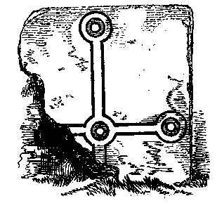
having been one of those corbel stones so often seen projecting in old Irish churches, and of which there is an example in the north-east angle of the gable of the neighbouring "Church of the Saints." It has at top two crosses on the west, two on the east (as shown in the accompanying illustrations), two on the south, and one on the north face, which may be regarded as examples of the most ancient carvings of that sacred emblem now to be found in the British Isles, or perhaps, if we except those in the Catacombs of Rome, anywhere in Europe.
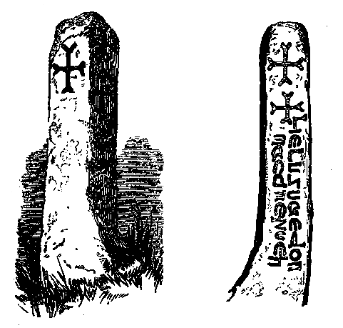
On the first face is an inscription, in the Uncial or old Latin character, here reproduced from a most careful rubbing.It reads perpendicularly, and was first published in 1845 by the late Dr. Petrie, in his celebrated work upon "The Ecclesiastical Architecture and Round Towers of Ireland," as Lie Lugnaedon Macc Limenueh "the Stone of Lugnaedon, son of Limenueh," the sister of St. Patrick.Taking the authorities in consecutive order it may be observed that Roderick O Flaherty, who first informed us of the ancient name of this island, makes no allusion to this monolith.In 181O an officer quartered in Galway described it in a local newspaper, and an Irish-speakulg soldier of his regiment gave a fanciful interpretation of its inscription.
In 1839 our great topographer, John O Donovan then employed upon the Ordnance Survey, visted the island, along with Mr. Wakeman, who made most careful drawings of the stone,and all the other object of antiquarian interest in connexion with these two churches; and O Donovan's illustrated communication of the 27th of June in that year is preserved in that great repertory of Irish history, see The Ordnance Letters of the Antiquities of the County of Galway, vol. iii, page 46 now in the Library of the Royal Irish Academy.
With reference to this stone he writes thus at page 50: It "exhibits a very ancient inscription, in the Roman characters, of the fifth or very beginning of the sixth century"; and adds, "That this Lugnaedon Macc Limenueh was no other than Praesbyter Lugnath, who was the son of Liemania, otherwise Darerca, the sister of St. Patrick, is highly probable, though we have no account of his having lived or being buried in this island.According to the `Book of Lecan,' fol. 5I, p. 5, col. b Presbyter Lugna (otherwise called Lugnath), was the alumnus of St. Patrick, and son of his sister; and he was located at a place called Fearta, in Tír Féig, on Loch Mask, where Duí Teanga Umha, King of Connacht, gave him and his fellow-labourers the lands extending from that part of Loch Mask called Snámh Tíre Féig to Sail Dea.In the same MS., fol. 45, a I, he is called St. Patrick's Luamaire or navigator.The Irish authorities are not, however, all agreed upon the history of this saint, some making him the son of St. Patrick's sister Lupita, some of his sister Darerca, and others of Liemania ! But this stone is a co-temporaneous monument, and should be received as historical evidence to prove that he was the son of Liemania.This inscription is the oldest Christian monument I have yet seen; and, whatever doubts there may be about the history of this saint, as given in the Irish MSS., there can be none about the authenticity of this inscription."
A short distance to the south-east is the second building
--Teampull na Naomh, "the church of the Saints," and an
ancient flagged way, seventy-nine yards long, leads between the two.It
is a more modern and highly decorated structure than that called after
our great Irish missionary, and lies nearly due east and west.It
measures thirty-eight feet one inch from out to out, of which
twenty-six feet four inches is the length of the wall of the nave, and
eleven feet nine inches that of the recessed chancel, which is five
feet eleven inches wide at the eastern end.The masonry of this church
is, to a certain extent,
laid in courses, except a portion of the south wall, which is very
massive, or what is called Cyclopean; but the quoins and several other
stones were dressed.Projecting from the north-east angle of the wall
of the nave is a
remarkable corbel-shaped stone, two feet for inches long, that reminds one
strongly of the Lugnaedon pillar, and strengthens the opinion given at
p61.
Here are shown the doorways of the Inis a' Ghaill churches. The first
represents the plain, severe, square-headed doorway of the primitive church,
or Teampull Phádraig. And on the oposite side we have
represented the beautiful, highly decorated, circular-arched, cluster
pillared doorway of Teampull na Naomh, and between the
erection of which and the former, some centuries must have
elapsed.This marvellous doorway, which is a grand specimen of early
Irish decorative art, is decidedly anterior to the date of the
Anglo-Norman conquest.
 Like its elder brother adjoining, it is placed on the western gable, and its
jambs slope slightly inwards.[fn65-1] Its dimensions are five feet eleven
inches from the lower edge of the arch to the sill, two feet two
inches wide at bottom,
Like its elder brother adjoining, it is placed on the western gable, and its
jambs slope slightly inwards.[fn65-1] Its dimensions are five feet eleven
inches from the lower edge of the arch to the sill, two feet two
inches wide at bottom,
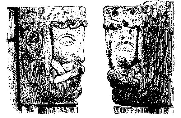
The jambs are formed by columnar pilasters, which are crowned by human-face capitals, from which springs the arch, the middle portion of which is carved into deep, horizontally projecting chevrons, over which is a row of faces, each differing from the other, and which may, for aught we know, have been portraits; but all are now so much defaced by weathering on the surface, and by the pitting already alluded to, as to efface their individuality.
The impost capitals are of exceeding interest, as they show a form
of beard plaiting and knotted hair work
rarely represented in sculpture.
These, on the north and south sides, are most faithfully represented in
the annexed cut.A similar form of decoration is to be seen on the fillet
underneath the cap of the Round Tower of Devenish
on Loch Erne, which is probably of contemporaneous antiquity.The
entire space included by the pillars and mouldings of this entrance is
four feet ten inches.Upon entering the church, the view here figured,
presents us with the low undecorated chancel-arch, altar, and deeply
splayed round-headed eastern light.This arch measures eight feet
seven inches in span; and from the keystone to the flagging beneath is
nine feet seven inches.
The nave is twenty-one feet seven inches by twelve feet nine inches
in the clear; and in the south wall there is a small, narrow,
round-headed light, six feet from the ground, and deeply splayed
inside.In the western corner of that wall may be seen one of the most
remarkable
 pieces of carving on the island.It consists of a flat,
irregularly-shaped, reddish stone, two feet two inches high, and three
feet ten inches wide, built into the masonry in this Cyclopean wall,
of which it evidently formed an original part.Indented upon its
surface is the very ancient Greek or Byzantine cross here figured, the
base or skeleton of which is of the same type as that on the stone of
St. Brecán, at the Seven Churches in Aran Mór, and on many ancient
Irish tombstones.It is said that a similar cross exists at
Ard-Oileán, or "High-Island," opposite the coast of Conamara.
pieces of carving on the island.It consists of a flat,
irregularly-shaped, reddish stone, two feet two inches high, and three
feet ten inches wide, built into the masonry in this Cyclopean wall,
of which it evidently formed an original part.Indented upon its
surface is the very ancient Greek or Byzantine cross here figured, the
base or skeleton of which is of the same type as that on the stone of
St. Brecán, at the Seven Churches in Aran Mór, and on many ancient
Irish tombstones.It is said that a similar cross exists at
Ard-Oileán, or "High-Island," opposite the coast of Conamara.
The stone altar of this church is still perfect, and measures four feet seven inches, by three feet four inches wide, and one foot ten inches high.Upon it are two remarkable indented stones: one has an oblong quadrilateral hollow, six and a half inches long, by four wide; the other, placed immediately under the small, eastern, round-headed single light, is a smooth stone, with an oval-shaped depression, six by four inches in diameter, capable of holding the closed fist--probably a very early font.It belongs to that class of cupped stones called in Aran, where they abound, Bulláns, and of which there are many at Gleann Dá Loch in Wicklow, of which "the deer stone" may be cited as an example.--See page 82.
On a stone of the ancient flagged way leading up to the western end of this church, is carved a square cross, with fish-tail terminations, like those on Lugnaedon's stone, and which is, no doubt, of great antiquity also.
Outside the north-east angle is a piece of square masonry, ten and a half feet by seven feet eight inches, and about four feet high, believed to be the tomb of Muirgheas Ó Nioc, Archbishop of Tuaim, who died here in 1128.
O Flaherty, in whose footsteps we have been treading, wrote thus of this island in 1684: "Inis a' Ghaill, so called of a certain holy person who there lived of old, known only by the name of An Gall Cráibhtheach, i.e. the devout foreigner; for Gall (i.e. of the Gallick nation), they call every foreigner.So Inis an Ghaill, or the foreigner's island, between Ross and Moycullen barony on Loch Oirbsen, contains half a quarter of pleasant land belonging to Cong Abbey, and hath a fine chappell therein, which is not for the buriall of any body." And further adds, that it "hath two chapells, the one dedicated to St. Patrick, the other to the saint of whom the island is named, which admits not the buriall of any body, but in the first it is usuall to bury."
Running out from the land in a western direction, and about a mile in length, is the long, low, narrow Island of Inis mhic a' trír, containing a few cottages, the meagre ruins of an ancient church, and also a burial ground.Of this ecclesiastical building we have no account; and there is not a single stone left whereby to judge of its style.It is, however, probable that on this island, as well as on the neighbouring one of Inchiquin, to which it is second in size, may have been erected one of those religious establishments referred to the times of Brendan, Maeldun, and Fursa; for there is great difficulty in determining the precise topography of many of the places in this district mentioned by the hagiologists; and when Colgan wrote he was evidently not personally acquainted with the locality, and his sources of research were chiefly Continental.The shores of this island abound with those peculiar perforated limestones already referred to and at the eastern end they form a causeway, which, with the aid of "a plank," connects it in summer time with the mainland.
The derivation of the name seems to be Inis mhic a' trír, "the island of the son of the three."
Taking up our itinerary where we left it, at the north-western angle of the parish of Shrule, we meet the little churchyard of Billapark, one of a group of several such which stud this corner of the parish of Cong.Then we approach Houndswood, a little to the north-west of which commences, with Cathair Muigheó, that vast assemblage of stone forts, cairns, and circles, that culminate at Nymphsfield.
The river of Cross opens into the northern end of a deep bay, surrounded on the north by the woods of Ballymagibbon.In this deep bay there are a great number of small islands, upon one of which (Gibbs'), near "The salt house," there are persons now living who remember the timbers of a surrounding stockade rising above low water; so that it may fairly be conjectured, that crannógs existed here and in other parts of Loch Coirib in early times.
Two roads on the west, and two others on the east, uniting at acute angles on each side of a small river running into Loch Coirib, give, together with a mill, dispensary, bridge, schoolhouse, a couple of shops, some cottages, a forge, and a public-house, etc., the name of "Cross" to a village of some note and antiquity.
About a mile to the north-east of this village, on the Kilmaine
road, stands an antique quadrangular tower, commonly known as "The
Castle of Cross;" and attached to its eastern side are the ruins of
an early, and in some of its architectural details rather interesting
church of which the two following cuts are highly illustrative,
although it has not been thought worthy of recognition on the Ordnance
Maps.The tower, which is exceedingly massive and well built, is now
twenty-two feet high, and measures twenty-five feet on the east, and
sixteen on the south side: and its walls are three feet three inches
thick.It has a narrow light on each face; and its pointed doorway,
leading from the church, opens into a stone-roofed apartment, topped
by another similar chamber, the only access to which is by a square
aperture in the floor over the outer doorway, like those seen in secular
defensive edifices.In all probability this tower, which was evidently
constructed along with the church, was used not merely as a belfry,
but as a residence for the clerics, and in troubled times a place of
security for the people and the ecclesiastical valuables, just as it
is believed the round towers were.A great many churches in Ireland of
the same architectural
 character as that of Cross are furnished with towers; and, as if
carrying out the idea of the primitive round tower, their architects
have almost invariably placed their doorways at a considerable
distance above the ground.A striking example occurs at Corcomroe, in
Clare, where the only opening giving access to the belfry tower is a
square-headed doorway, placed about twelve feet from the ground.The
church itself is forty feet long and nineteen wide, on the inside.Its
northern wall is thirteen feet six inches high, and the east gable is
still standing, but formed of small stones, undressed, except at the
angles, and in the double-lighted eastern window.The latter is
deserving of a careful inspection, as its masonry exhibits a curious
instance of economy and adaptation.The superincumbent weight of the
gable is relieved by a solid arch of undressed stone below.Although
the division between the lights, and also their outer edges, are all
composed of chiselled stone, their inner jambs, a portion of the
splays, and all the soffit and arches, are ingeniously
character as that of Cross are furnished with towers; and, as if
carrying out the idea of the primitive round tower, their architects
have almost invariably placed their doorways at a considerable
distance above the ground.A striking example occurs at Corcomroe, in
Clare, where the only opening giving access to the belfry tower is a
square-headed doorway, placed about twelve feet from the ground.The
church itself is forty feet long and nineteen wide, on the inside.Its
northern wall is thirteen feet six inches high, and the east gable is
still standing, but formed of small stones, undressed, except at the
angles, and in the double-lighted eastern window.The latter is
deserving of a careful inspection, as its masonry exhibits a curious
instance of economy and adaptation.The superincumbent weight of the
gable is relieved by a solid arch of undressed stone below.Although
the division between the lights, and also their outer edges, are all
composed of chiselled stone, their inner jambs, a portion of the
splays, and all the soffit and arches, are ingeniously
 constructed of carefully-selected blocks, that do not show the
slightest trace of either chisel, punch, or hammer, as may be seen in
the accompanying illustration. Although there are many legends afloat
anent cailleachs, witches with black-hafted knives, "weird sisters,"
and belated travellers, there is no real history of this building.It
is situated in the townland of "Attyickard," as it is spelled on the
map, but the proper name of which is Áit Tighe Riocaird,
"The site of Richard's House," probably because a Burke had a hand
in the construction of its castellated tower.To the south and west
may be seen in a few minutes' walk several ancient remains--circles,
forts, traces of Pagan sculptures, and caves--one of the latter in
particular sunk in the middle of a fort, adjoining the
constructed of carefully-selected blocks, that do not show the
slightest trace of either chisel, punch, or hammer, as may be seen in
the accompanying illustration. Although there are many legends afloat
anent cailleachs, witches with black-hafted knives, "weird sisters,"
and belated travellers, there is no real history of this building.It
is situated in the townland of "Attyickard," as it is spelled on the
map, but the proper name of which is Áit Tighe Riocaird,
"The site of Richard's House," probably because a Burke had a hand
in the construction of its castellated tower.To the south and west
may be seen in a few minutes' walk several ancient remains--circles,
forts, traces of Pagan sculptures, and caves--one of the latter in
particular sunk in the middle of a fort, adjoining the
 site of the dilapidated village of the same name as the townland, is
worthy of inspection.
site of the dilapidated village of the same name as the townland, is
worthy of inspection.
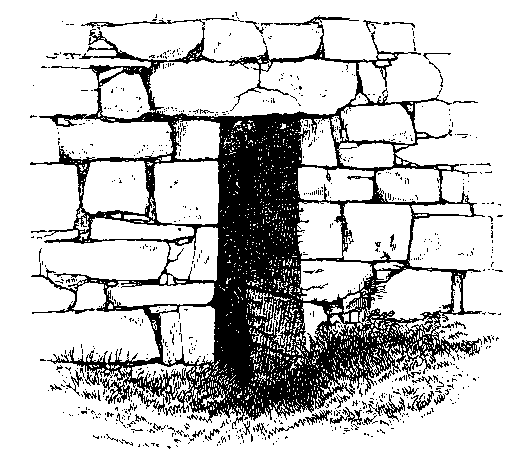
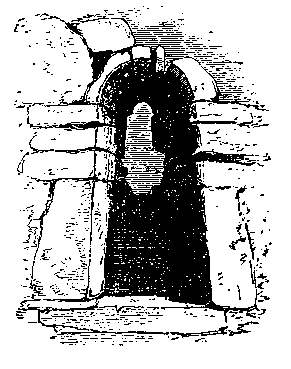
Returning to Cross, and in the grounds of Dumhach, we must visit one of the very oldest primitive Cyclopean churches in Ireland, and undoubtedly the most remarkable that occurs in our route--that of St. Fraochán, the square-headed western doorway of which is here shown. Its walls are now seven feet high on an average, and two feet thick; its length is eighteen feet inside, twelve feet at the west, and fourteen in breadth at the east end--a remarkable peculiarity. There are no remains of window apertures, as the east gable is no longer standing.The doorway here figured is five feet eight inches high, and two feet three inches wide at bottom, the jambs inclining to one foot eleven inches at top, where they are covered by a massive lintel, three feet ten inches long, which spans the entire wall.The inner faces of the jamb stones are smooth, as at Cill Fhursa.
That this building is a representative of the primitive Oratory and dwellinghouse of an early Irish saint, there can be no doubt.It was divided into an upper and lower apartment by a flat floor, some of the corbels of which yet remain; and the space between this and the roof was, no doubt, the saint's sleeping apartment.We find the same arrangement in St. Kevin's Kitchen, St. Columba's House at Kells, Molua's House, and other buildings of the same peculiar class.The only difference between Kilfraughan and the others just mentioned is, that it had a dividing floor of timber, and the others one of stone, resting upon a barrel arch.This charming little ruin, which stands in the middle of a very ancient burial ground, and is surrounded by antique hollies and thorns, is highly venerated by the people, among whom there is a tradition, that from it was brought the clay with which the Abbey of Cong was consecrated.
Of St. Fraochán, if such a personage existed here, we know nothing;
and our annals, calendars, martyrologies, and the saints' lives make
no mention of him.The ancient name of this church, and one which is
still living among the old people, is Cill árd-chraobh na
Naomh--literally, "the church of the high branch of the saints."
Below its east end is a spring well of never-failing purity and
supply, which, in fine weather, when the turlochs are dry, affords
water for the neighbouring mill, and pours
 its stream into the Cross river.To the north of this locality is
Garra Cluana.
its stream into the Cross river.To the north of this locality is
Garra Cluana.
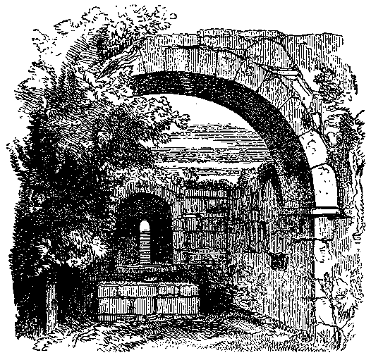
Continuing our route on to the village of Cong, through the great cairn-studded plain of Moytura, we meet another small ancient church called Cill Ársa, in the townland of Ballymagibbon, of which twelve feet high of the east gable, with a small, round arched window in it, still remains, as shown in the accompanying cut; as also so much of the side walls as to give the measurement of its interior as twenty- four feet long by sixteen and a half feet broad.[fn77-1] Again, a little nearer the lake, in the village of Gort a' churra, "the field of the currach" (scrub or bottom), there formerly existed the ruins of a very small church, some of the large stones of which may still be discerned in the adjoining walls and cottages.
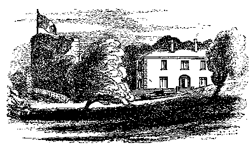
From the hill of Tonlegee, overlooking this latter locality, was
taken the accompanying view of Moytura
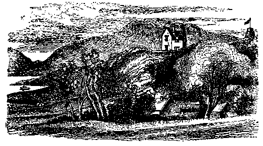
House, the residence of the Author, erected in 1865; and so called after the ancient battle-field on which it stands, with Benlevi Mountain in the distance, and Loch Coirib in front.The tower with the flagstaff stands within the enclosure of one of the ancient cathairs of the battle field.This house commands a magnificent prospect to the west, south, and east, and can be seen from most parts of the middle lake.To the west of Moytura is Leaca In the wall of this church there was, a few years ago, a carved stone, having in relief the figure of a child. It is now built into a coach-house in the vicinity. Fionna--"white flagstones"; and still nearer to Cong, over a small bay of the lake, stands Lios Luachra--"the rushy liss," or earthen fort.
From this point the mountain view presents one of its best aspects,
and the shores of Mayo and Galway, sloping down to the water's edge,
are in many places pleasingly wooded.Leaving Coad Island on the
left, we get among a group of islets at the mouth of the river, the
outermost of which, Oileán Rí, or "the king's island," was said to
have been a favourite retreat of O Conor, the last Irish monarch,
while sojourning in the neighbouring abbey; and nearer the shore are
Inis Cunga and Oileán Dara.