4. Coill Bheag to Inis Uí
Chuinn

COILL BEAG TO INIS UÍ CHUINN
THE PARISH OF CAIRRGÍN, ALTHOUGH small in extent, is one of great
interest in an historic and pictorial point of view. It extends
eastwards between that of Cill Éanna, on the south-east, and Cill
Fhursa, on the north-west, over a space about three miles long, and
one broad; but owing to the wooded promontories of Coill Beag and
Claoideach, its shore margin is of much greater extent; and between
these projections, a deep bay passes inwards for about three-quarters
of a mile.
The old church of this parish is of no great interest or antiquity,
and neither to it nor to this parish itself is the term "Cill"
applied, but the ruin is called Séipéil a' Chairrgín,
"The Chapel of Cargin," and in all probability it was a chapel of ease
to some of the saints' churches in the neighbouring parishes.Around
it are the remains of a circular rath, and beside it a Cillin, or
children's burial ground, of which class of cemetery there are great
numbers in the West, but especially along the shores of Lochs Coirib
and Measca. [fn38-1]
The ruined Castle of Cairrg;;n, here presented, stands on an eminence
at the extremity of the little bay.There is no history, nor are there
any legends attaching to this ancient castle, which measures externally
forty feet by thirty. [fn38-2]
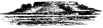
In the little bay in front stands Inis creamha, or "wildgarlic
Isle,"where, says O Flaherty, in his `West Connacht,' "the walls
and high ditch of a well-fortified place are still extant, and
encompass almost the whole island. Of this isle, Macamh Insicreawa, a
memorable antient magician, as they say, had his denomination. Anno
1225, the Lord Justice of Ireland, coming into the port of Iniscreawa,
caused Odo O Flaherty, Lord of West Connacht, to deliver that island,
Kirke Island, and all the boats of Lough Orbsen, into the hands of Odo
O Connor, King of Connacht (Cathald Redfist's son) for assurance of
his fidelity."
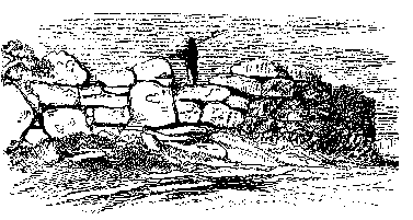
The great uncemented Cyclopean stone fort to which this extract
refers still encircles the brow of the little island, as shown in the
following illustration, but the scrubby brushwood around it partially
obscures the masonry, which stands over a deep trench or fosse, that
must have rendered its capture a matter of much difficulty before the
general introduction of fire-arms.In all probability it served like a
crannóg to guard Cairrgín
 Castle, or as a safe refuge for the persons and valuables of its
inmates, or those of the surrounding country.There can, however, be no
doubt that this structure belongs to the days of the unmortared dúns,
cahers, and cashels long prior to the date of the Anglo-Norman
invasion.The walls average six feet thick, and are still ten and a
half feet high; but the stones of which they are composed, owing in all
probability to the fact of their having been carried from the
neighbouring mainland, are of comparatively small size.They enclose
an oval space of one hundred and forty-four yards in circumference;
and the doorway is on the east or land side, where the ditch is level
to afford means of access.The present name of the island on the
Ordnance Map is Ilaun Carbery, because a fanatic named Carbery lived
for many years during the eighteenth century in a hut he built for
himself within the enclosure.
Castle, or as a safe refuge for the persons and valuables of its
inmates, or those of the surrounding country.There can, however, be no
doubt that this structure belongs to the days of the unmortared dúns,
cahers, and cashels long prior to the date of the Anglo-Norman
invasion.The walls average six feet thick, and are still ten and a
half feet high; but the stones of which they are composed, owing in all
probability to the fact of their having been carried from the
neighbouring mainland, are of comparatively small size.They enclose
an oval space of one hundred and forty-four yards in circumference;
and the doorway is on the east or land side, where the ditch is level
to afford means of access.The present name of the island on the
Ordnance Map is Ilaun Carbery, because a fanatic named Carbery lived
for many years during the eighteenth century in a hut he built for
himself within the enclosure.
To the foregoing notice of the depredations upon Loch Coirib in
early times may be added the following, A.D. 929: "The Danes of
Limerick took possession of Loch Oirbsen, and pillaged its islands."
A.D. 1061 the O Flahertys of the adjoining territory of Magh Seóla,
already referred to above took possession of Loch Coirib, and expelled
Aodh O Conor; and in 1224, after the death of Cathal Crobhdearg, the
red-handed son of King Turloch, and during the contentions between the
O Conors of Connacht, Aodh, the son of Cathal, compelled the O
Flahertys to deliver up this island, as referred to in the foregoing
extract.
In 1233 Felim O Conor, King of Connacht "demolished the castles of
Kirk Island, Galway, Hag Island, and Dún na mBan." Again, "in 1256
Walter De Burgo, Lord of Connacht, and first Earl of Ulster, marched
against Roderick O Flaherty, plundered the territories of Gnó Mór and
Gnó Beg, west of Loch Orbsen, and took possession of the lake, its
islands and castles.These he fortified, and by that means
considerably increased the power of the English in Connacht." In all
probability it was at this period, and from thence up to 1450, that
the great majority of the De Burgo Castles in this district were built
or remodelled.
About two miles east of the lake, in this parish, stands Cathair
Geal, or "Whitefort," one of the finest specimens of ancient military
architecture on the mainland of Ireland, and which can easily be
reached by the roads leading from Coill Beag or Claoideach to
Headford.From its colour it gives its English name to the townland,
as, for similar reasons, we meet with the names of Roundfort and
Darkfort, etc., in other localities.
The magnificent circular Cyclopean building, a portion of the
external face of which is well shown in the subjoined illustration,
encloses a space of one hundred and thirty-seven feet in diameter; and
its massive walls of unhewn stone, of a whitish hue from the lichens
covering them, are nine feet four inches thick, and, although lowered
in many places, still average seven feet seven inches high.
The entrance on the south-eastern side, over the road leading to a
farm house, is seven feet six inches wide; its external jambs,
measuring five feet eight inches over ground, are each five feet
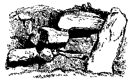
broad, and twenty-one inches thick.Inside, on the south-east, is a
fight of three massive steps, figured on the next page, which probably
led to a parapet, as at Stague fort, in Kerry.Within the enclosure
there are the remains of several intersecting walls; but, as the space
is grass-grown, it is difficult to say whether they are the ruins of
Clocháns,[fn42-1] of which there is a tradition.
To the west of the Galway road, near where it joins that of
Killursa, may be seen a remarkable ancient enclosure, with several
standing stones circling the brow of a small hill, and called
Lisín na Péiste, or the "little fort of the serpent," or worm.
Killursa--properly Cill Fhursa, in commemoration of Fursaeus, a
celebrated Irish saint and traveller--margins
Loch Coirib, in continuation of Cairrgín, on the south; and forms the
terminal parish of the barony of Clare, and county of Galway, on its
eastern shore.Its northern boundary is the Abhainn Dubh, or
"Black River," which, passing under ground below Shrule, rises again to
the surface to the east of the castle of Moyne, and, running by the ruins
of Ross, enters the lake about a mile beyond the castle of Annakeen.
Irish hagiology abounds with notices of the Christian celebrities of
this district in the sixth and seventh centuries.In the large island
of Inchiquin, belonging to this parish, and now on our starboard
quarter, it is stated that St. Brendan founded a religious
establishment, which was afterwards increased by St. Maeldun, of the
Ua Cuinn family, from which the Island of Inis Uí Chuinn took its
name.Fintán, King of Munster, with his Queen, Gelgéis, daughter of
the King of Connacht, in consequence of some troubles in his province,
fled to Loch Coirib, and was hospitably entertained by his relative,
Brendan; and while residing with him in his Cella Hospitum at
Rathmath, in Inchiquin, had a son, who was christened Fursa, or
Fursaeus.He flourished between A.D. 584 and 652, and his festival is
kept on the 16th of January; but several other days are given in Irish
ecclesiastical writings for that event.He is said traditionally to
have had two brothers, Enda or Éanna, and Cuana, who have given names
to the adjoining parishes of Killeany and Kilcuana, as stated at page
35.
Killursa is now united with Cairrgín, and also with Killannin on the
opposite shore of the lake, in the Catholic Parish of Headford.
Not far away, but in the parish of Killursa is the castle of Eanach
Caoin.It is a square keep, the outer walls of which are perfect,
except upon the north side.That upon the lake or west side is
forty-six feet long, and that on the south, here represented, is fifty
feet.There are also some remains of the outer enclosure, and the
whole is surrounded by a very beautiful park of the finest land,
ornamented with some aged ash.Of all the castles surrounding Loch
Coirib, this would appear from its masonry to be the oldest; for,
although it has not been dilapidated for building purposes, it is not
possible to find in it or around it a single dressed stone of any
description; the quoins, door-ways, and window openings being, with
the walls, both within and without, all formed of undressed stone.At
the north-west corner there is a square tower, and probably a similar
one existed on the north-east. All the outer
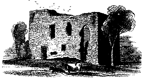 walls of this structure are six feet thick, and contain passages
leading to the upper apartments and the parapet.Some of the arches of
the windows and doors are circular, and others pointed; but all
ingeniously constructed with stones to which a hammer or chisel was
never applied--in like manner as in the arch of the east window in the
beautiful old church of Cross, and as we find in other localities
where the great abundance and variety in form of the surrounding
limestone afforded ample materials for any description of building,
and the ingenuity of the artists was equal to the task of rendering
them subservient to architectural purposes.Even to the present day,
every man in this and the adjoining limestone districts is more or
less a mason.
walls of this structure are six feet thick, and contain passages
leading to the upper apartments and the parapet.Some of the arches of
the windows and doors are circular, and others pointed; but all
ingeniously constructed with stones to which a hammer or chisel was
never applied--in like manner as in the arch of the east window in the
beautiful old church of Cross, and as we find in other localities
where the great abundance and variety in form of the surrounding
limestone afforded ample materials for any description of building,
and the ingenuity of the artists was equal to the task of rendering
them subservient to architectural purposes.Even to the present day,
every man in this and the adjoining limestone districts is more or
less a mason.
Among the structural peculiarities of this castle is that of having
upon the outer face of the ground story small, low, arched apertures
leading into guard rooms or sentry cells, but in other instances
communicating with the walled passages above.The marking of the
wattled centering upon which the arches were laid, so many centuries
ago, shows the great strength of the mortar used at the time of their
erection; for it is as hard and sharp as when the basket-work, on
which it was raised, was removed; and in the upper apartment of the
northwest tower the roof is perfectly flat.
As there is no stone now remaining at Annakeen to afford us a clue
to the date of its erection, neither is there any history which throws
much light upon the subject.That, however, it was a place of note in
very early times, may be learned from the fact that Mac Uilliam
Uachtar son of Sir William the Grey, and the progenitor of the
Clan-Rickard, was called "Ulicus de Anaghkeen"; and certainly the
architecture of the castle may with safety be ascribed to a date six
and a half centuries ago. [fn45-1]
Here, as elsewhere throughout Ireland, the ruins are grouped with
others of different eras and uses.A little to the east of the old
castle there are the vestiges of the church and burial ground of St.
Cróinín; and a short distance to the north-east there of a considerable
cairn, which may be seen from the lake, crowns an eminence in a
neighbouring field; while, following the inland road, we soon arrive
at Dúnáin Fort and Eidhneach graveyard, in the townland of Carrowakil,
on the south of the road opposite which there is one of those early
Pagan structures known as "giants' graves," and here significantly
called by the people Leaba'n Fhir Mhóir,--the bed or "grave of the
big man." The fort has recently been in great part obliterated, although a
few of the large flagstones are still standing; and, as it is asserted
that human bones of large dimensions were found in it, I may here
remark that no human bones of a gigantic size were ever found in an
Irish burial place, either ancient or modern.The Leaba crowns a
little mammillary elevation, and consists of an oblong enclosure,
running nearly east and west, and having at the eastern end several of
the large upright flagstones still remaining.These "giants' graves"
are not uncommon, although not of such frequent occurrence as the
stone circles, the inner enclosure of which originally supported the
hive-shaped domes.
Passing beside Clover Hill in an easterly direction, by St. Ciarán's
Well, and through a group of ancient forts and raths, we reach the
extensive graveyard and ruined church of Killursa, erroneously styled
on the Ordnance Map Kildaree, from the neighbouring townland of that
name, although O Donovan, in his letters, has given a distinct
description of it, as well as a drawing of the western doorway, which
forms a remarkable feature of this ruin.All the walls are still
standing, although considerably dilapidated; it was of the Daimhliag
mór class of church, and measures seventy feet six inches, by
twenty-four feet on the outside.The southern doorway is a pointed
arch; and the east window, which, compared with the extent of the
building, is of unusual height was a fine specimen of pointed Gothic
architecture, and was probably erected in the sixteenth century; it is
eleven feet six inches high, and three feet four inches in the clear.
The well-cut stone mullions still remain; but the outer spaces were
built up years ago, when, perhaps, the poverty or persecution of the
parishioners prevented its repair.A cross wall cuts off nine feet four
inches of the western end, which portion was probably occupied in later
times by the officiating priest or friar.A similar wall exists in the
little church of Ross Hill, at Loch Measca.
The characteristic feature of this church is the small square-headed
sloping-jambed doorway, near the southem angle of the western gable, of
the great antiquity of which there can be no doubt; and which is
probably a remnant of the early church founded here by St. Fursa, when
disgusted with the state of affairs at Inchiquin, he came over to the
mainland, and established a religious house in this parish.The
dimensions of this doorway are--five feet four inches in height, two
feet wide at top, and two feet five inches at the bottom.Nearly all
the stones of its sides occupy the entire thickness of the wall, which
here measures two feet, and are undressed on the ends; but upon the
inside they are all perfectly smooth, as if they had been first put in
their places in a rough state, and were then sawn or rubbed down into
their present condition.The lintel, which is a rough, unhewn,
weather-worn flag, three feet eight inches long, does not appear to
have been part of the original structure, and is quite incongruous
with the rest of the doorway, in openings of which class the lintel is
generally of great size and thickness.The probability is that, in the
original church, the doorway stood in the centre of the west gable;
and that when, in the process of centuries, the present church was
reconstructed on the site of the old, it was enlarged towards the
north, as well as in length, the doorway being left in situ, and the
present lintel placed upon it.
These square-headed, so-called Cyclopean doorways, with sloping
sides, are characteristic of our very early Irish churches; although,
as in the case of that at Inishmain on Loch Measca, they are
occasionally associated with the florid architecture of a much more
recent period, and evidently of foreign introduction.They abound in
the Loch Coirib district, as at Cill Chathail, below Cnoc na dTuagh,[fn48-1]
Cill Fraochán, Inis Meadhon, Ross Hill, Inis a'Ghaill, and Cill
Aithnín.
Looking north-eastward from Killursa church into the fertile valley
through which the Abhainn Dubh flows, the eye rests on the picturesque
ruins of Ross-Errilly, depicted below.Upon a slight elevation on the
Galway bank of the river, surrounded by fat pasture lands, and
approached by a long avenue, or causeway, on the south, stand the
extensive ruins of this Franciscan convent and church, which are thus
referred to by the Donegal Annalists: "A.D. 1351, The monastery of Ros
Oirbhealaigh in the diocese of Tuam, was erected for Franciscans." In
1604, Brian Óg Ó Ruairc was buried there, the name is spelt
Ross-Iriala.
In this entry the following legend still exists: The building was
commenced at Ros Daimh on the north or Mayo side of the river, when
three swans came and perched on it, and having remained some time,
flew to
 the other side with some ros, or flaxseed, which there grew up
forthwith; and then the former structure was deserted, and the present
commenced, and called Ros na tír Eala, "the flaxseed
of the three
swans!"
the other side with some ros, or flaxseed, which there grew up
forthwith; and then the former structure was deserted, and the present
commenced, and called Ros na tír Eala, "the flaxseed
of the three
swans!"
The illustration has been taken from the south-east from which point
the best general view of this charming group of ruins may be obtained.
The house to the extreme right of the picture, called "Castle Burke,"
was probably the private residence of the Guardian, or the Provincial,
who occasionally resided there.The church was not built cruciform, as
in the case of its brethren at Cill Conaill and Clare-Galway, but the
high central tower, supported on pointed arches, springs from the
junction of nave and chancel.The gables on the left are those of
additions, and that in the centre, of a mortuary chapel.Popularly,
but erroneously, this building is styled an "abbey," as in the
instances of the two last named edifices; but an abbey can only
pertain to a community governed by an Abbot, which office did not
belong to the Franciscan Order.Before examining the ruins in detail,
let us read what was written of them two hundred and fifty years ago.
In 1617, two Irish Franciscans, Fathers Purcell and Mooney, were
resident at Louvain, where they and their Order had, after their
expulsion from Ireland, been protected by Albert and Isabella, then
joint sovereigns of the Netherlands.Fr. Mooney, at that time
Provincial, and far advanced in years, had been in early life a
soldier, and served in the Desmond wars.Purcell was a man of great
learning; and, from materials supplied him by his superior, wrote,
partly as a dialogue, a Latin history of his Order, so far as it
related to their Irish establishments. This interesting MS., the
original of which is in the Burgundian Library at Brussels, the Rev.
C. P. Meehan, of Dublin, has translated and published.Fr. Mooney's
recollections of this monastery are thus afforded by his ancient
scribe and moderm commentator:
"Never was a more solitary spot chosen for the habitation of a
religious community than that one on which Rosserilly stands; for it
is surrounded by marshes and bogs, and the stillness that reigns there
is seldom broken, save by the tolling of the church bell, or the whirr
of the countless flocks of plover and other wild birds that frequent
the fens which abound in that desolate region.Another remarkable
feature of the locality is, that the monastery can only be approached
by a causeway, paved with large stones, over an extent of fully two
hundred paces, and terminating at the enclosure, which was built in
1572 by Father Ferrall Mac Egan, a native of Connacht, and then
Provincial of the Irish Franciscans.He was, in sooth, a distinguished
man in his day, far-famed for eloquence and learning, and singularly
fond of Rosserilly, which he used to compare to the Thebaid, whither
the early Christians fled for prayer and contemplation.He died in our
house of Kilconnell, where he made his religious profession, and there
he awaits the resurrection--peace to his memory! As to the church of
Rosserilly, it is, indeed, a beautiful edifice; and the same may be
said of the monastery, which, although often garrisoned by the English
troops during the late war, is still in excellent preservation.
Cloister, refectory, dormitory, chapter house, library, and lofty bell
tower, have all survived the disasters of that calamitous period; but,
in the twenty-sixth year of the reign of Elizabeth, the friars were
forcibly expelled from their beloved retreat."
The friars, however, soon returned, and remained in quiet possession
for long after, till Sir Arthur Chichester, then Lord Deputy, directed
O Donnell, or Daniel, Archbishop of Tuaim, to turn them out; but that
good and learned Protestant sent them word privately of his intention,
and they saved themselves and their effects by flight.One good turn
deserved another; and this kindness was repaid in 1641, when, after
the massacre at Shrule, Father Brian Kilkelly, then Guardian of
Rosserilly, hearing of the atrocities which were enacting within a few
miles of him, hastened to the spot, succoured the wounded, and brought
the Bishop of Killala's wife and children to his monastery, and
treated them with the greatest kindness.
Great changes have taken place in the surrounding scene since Father
Mooney's description was written.This site was in all probability a
Cluain, an "isolated meadow," or lawn; and there was originally a
water-course leading from some springs, pools, and turlochs, on the
southeast, which supplied a stream that turned a small mill, the
foundations of which still exist, and then passed by a conduit through
the kitchen on the northern side into a fish tank, or circular
reservoir, within the walls, the cut stone margin of which remains; so
that the fresh trout and curdy salmon from the neighbouring Abhainn
Dubh prevented the worthy friars from feeling the effects of
abstinence on fast days.
This kitchen is a spacious apartment, fitted up with oven, extensive
fire-place, and an aperture through which the smoking savoury viands
could be passed at once into the refectory, which adjoins its eastern
side.In the north-east corner of this refectory is a sedile, with a
handsome slender pillar support, in which the reader, in sonorous
tones, read to the fathers.Here, in former times, were interred, with
pomp, while bells tolled, friars chanted, and chieftains clad in all
the panoply of funereal state assisted at the ceremonial, the mortal
remains of the O Flaherties, O Donnells, Kirwans, Lynches, Brownes,
Mac Donnells, Burkes, Kilkellies, and other Connacht notabilities.
The total length of this great church is one hundred and
twenty-eight feet, and its breadth twenty and a half feet.The
arches between the nave and side aisle on the southern side, as we
enter from the west; the tall tower, seventy feet high, supported upon
pointed arches, that separates the nave and chancel; the beauteous
four-lighted east window, partially deformed though it be by the
unsightly modern tomb that occupies the situation of the high altar;
the coronetted tomb of the founder, recessed into the northern wall;
the low, deeply-moulded arches that lead into the side chapels; the
history of the families to whose memory the different mortuary chapels
were erected, and all the architectural details of this memorable
place, would occupy many pages to describe.There are many interesting
and peculiarly Irish architectural details in this ruin, among which
are the decoration of the bolt-hole in the western door-way, which
resembles some of the Newgrange carvings; the beautiful cross, a
fragment of which has been erected over a grave adjoining the modern
western wall; and the form of an ancient hatchet or Tuagh figured on
the tomb of the Thuhils in 1617, who probably derived their name from
that implement.The great bell, with its silver tongue, is, it is
said, occasionally heard to chime in its deep bed in the adjoining
river.
From the rolls of the Order we learn that in 1647 a chapter of
Franciscans was held here under the presidency of the Very Rev.
Anthony de Burgo; and also that it was occupied until 1687, when the
Rev. P. Ó Neill was elected Provincial, and the Rev. B. O Flaherty
Guardian and the friars prayed for James II and his consort, and his
Irish viceroy, Tirconnell . . . It is said that at a later period Lord
St. George aided the friars by placing some looms in the church when
the government sent down orders to dispossess them.
About a mile to the north-east of Rosserilly, but upon the Mayo side
of the river, and in the parish of Shrule stands the old castle of
Moyne, and a little beyond it the ruins of an ancient church.Besides
these different places already referred to or described in the parish
of Killursa, the following may be noted.The site of the ancient
"Church of the two Kings," Cill Dá Rí, from which the townland
of Killdaree has been called: Ard Fintáin and Cathair Fintáin, which also
gives name to a townland to the north-east of Killursa Church, where
also several raths and forts exist, and which is so-called after the
ancient king already referred to at page 99; Cathair na haille, now
called Cahernally, where the Kilkellys of old resided; and near the
church the remains of a cromleac, termed --as such structures usually
are, Leaba Dhiarmada's Gráinne --"the bed or resting place of
Dermod and Grania" during the period of their courtship and flight from Tara;
its top stone is nine and a half feet long.There are also forts and
raths along the shore, which are well worthy of inspection, especially
Lisín na Circe.
Appertaining to this parish, near its north-western end, and about
half a mile off shore, is the long, low island of Inchiquin, running
nearly north and south; which is upwards of a mile and a quarter in
length; it contains two hundred and twenty-nine acres, and is the
largest island in Loch Coirib. "On that island of Insequin," O
Flaherty says, as already referred to at page 43, "St. Brendan built
a chappell, and worked divers miracles.In the same island St. Meldan,
whose festivall day is on the 7th of February, was abbot of a fameous
abby about the year 580.He was spiritual father to the great St.
Furse, of Perone, in France; who carried the relicques of this saint
along with him, and enshrined them at Perone." The local habitation of
these early saints on Inchiquin was Rath Meadha, "the rath of Meadh"
--a name that has become very celebrated from its frequent mention in
Irish hagiology.Its outline still exists, but scarcely a vestige of
the walls of the ecclesiastical structures remains; the site is,
however, still used as a burial ground.Possibly the dilapidations
commenced here when " the isles of Loch Oirbsen were pillaged by the
Danes."Its Irish name is Inis Uí Chuinn--the island of the
descendants of Conn, Monarch of Ireland in the second century; and it
was so celebrated, that the entire lake is said at one time to have
been called Inis Uí Chuinn.Three Conns have been celebrated in Irish
history, and Conn Céadchathach, here referred to, was the ancestor of
St. Maeldun.It is said traditionally, that Ruairi Ó Conchubhair, when
on his way to Cong, after his abdication in 1183, rested at this
island; but, finding a favouring breeze, he said, "Well, if the land
is against me, the wind is with me" and so set sail for Oileán Rí
Footnotes
[fn38-1] Kii~een, a " little church "--applied to diminutive graveyards,
nearly always used for children, and generally for those who have died
unbaptized, respecting which many curious popular superstitions are
still afloat.
[fn38-2] In the state Paper styled " The Division of
Connacht," it is said that in I586 William Gaynard held the Castle of
Carigin; Mac Reamon, Cloghenwoyr; Moyler Mac Reamon, Annaghkyne;
Tybbot Lyogh, Loscananon; Ullig Rogh, Drumgrifiln; " Walter fitz-Ab,
fitz-Ed., Masse; ~ and McWalter's sept, Cahermorise ! all of which are
referred to in this work.
[fn42-1] Clochans are small uncemented, or dry-wall huts, generally
circular or oval in shape, and having their domed stone roofs
constructed with flags gradually projecting inwards like those of some
of the Pyramids--and the tumuli of Newgrange and Dowth, etc. They
abound in the Aran Isles, and in Kerry.
[fn45-1] In I586 Nicholas Lynch was possessed of the Castle of
Annaghcoyne; and when, in I619, James I confirmed the possession of
the Castle Hacket estate to the Burkes of that place, as was done to
all Irish proprietors who surrendered their estates for the purpose of
getting a new title to them, and erected the same the Manor of Castle
Hacket, the castle and lands of Annakeen are included in the list of
lands forming it.
[fn48-1] Kilcathail, the church of St. Cathaldus, stands by the
roadside, about four miles from Clare-Galway, on the way to
Tuaim.--see " lar-Chonnacht," p. 369. O Donovan has given a drawing of
it in his Ordnance Letters on Galway.
[Chapter 3]
[Chapter 5]