| Accommodation
|
What's On?
|
Travel
|
Webcams
Classified Ads | Local News | Photo Gallery | History Galway Arts Festival 2004 |
Salthill Airshow A Red Arrows Hawk aircraft pulls up from a dive during at the Salthill Airshow. Sunday 6 July 2003. Photo: Joe Desbonnet.
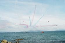 The Vixen Break at the end of the Red Arrows display. In the background is LE Ciara (Irish Naval Service) and the Clare mountains in the distance. Photo: Joe Desbonnet
Around Galway A labrador watches the sunset at Salthill, Sunday 6 April 2003. Photo: Joe Desbonnet
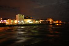 Claddagh at night. Photo: Joe Desbonnet
|
RV Celtic Explorer CommissioningRV Celtic Explorer, National Research Vessel, Commissioning 11th April 2003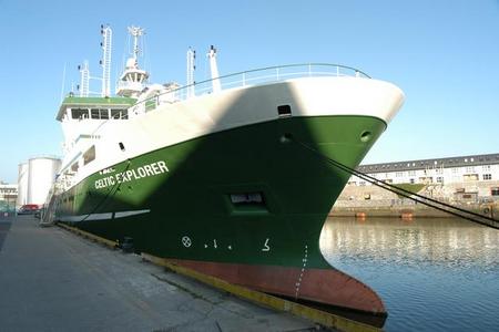
The national research vessel (RV) Celtic Explorer will be commissioned on April 11th 2003 at Galway Docks where it will be based close to the headquarters of the Marine Institute. To celebrate the commissioning the Marine Institute is hosting an exhibition on the docks Saturday and Sunday April 12th and 13th alongside the Celtic Explorer and Celtic Voyager at Galway docks. Both vessels will be open to the public from 12pm to 6pm Saturday and Sunday. This will provide a unique opportunity to visit Ireland’s national research vessels and meet the crew and scientists that work onboard. They will demonstrate the work they undertake onboard including fish stock assessments, environmental monitoring, the National Seabed Survey, deploying and servicing weather data buoys to increase safety at sea. The RV Celtic Explorer is a multipurpose research ship designed for deep-sea research and can stay at sea for up to 45 days accommodating 12 crew and up to 19 scientists. The laboratories and data management system onboard allow information to be collected and processed at sea and quickly relayed back to scientists, governments and industry groups to inform management decision on the sustainable development of the marine resource. The Celtic Explorer’s first mission will be to deploy a new weather buoy off the coast of Donegal. The M4 weather buoy will be the fourth in a network of five databuoys deployed and serviced by the Marine Institute around the Irish coast. The Celtic Explorer will commence work on the National Seabed Survey, one of the worlds largest and most ambitious seabed surveys, at the end of April. It will produce baseline maps of Ireland's offshore territory that will act as building blocks for industry and academia with wide ranging applications such as telecommunications, underwater slope hazard maps, mapping of habitats and other geological features, and protection of areas of scientific interest such as the Atlantic deep-water coral Lophellia. “Thanks to the support of the government, industry and the European Union, Ireland now has the keys it needs to unlock the potential of our greatest national resource – the ocean,” said Dr Peter Heffernan, CEO of the Marine Institute. “In the last eight years, we have managed to overtake eighty years of turning our backs on the sea. Ireland now has two purpose-built marine research vessels, open & competitive research programmes for industry, state and third level institutions, investment programmes in marine industry, a vibrant scientific community and the beginnings of a new hub for marine research and investment at Oranmore. If we can go as far in the next eight years as we have in the last eight, then Ireland will become a centre of excellence for marine research and investment second to none." The Celtic Explorer will complement the research capability of the Celtic Voyager, Ireland’s first custom-built multi-purpose research vessel designed for coastal surveys, which was commissioned in 1997. Both vessels are owned and managed by the Marine Institute on behalf of the state. The National Seabed Survey is being undertaken by the Geological Survey of Ireland in collaboration with the Marine Institute. Related Links
|