Chapter 9: Loch Measga
- chapter 9
Return to table of contents
Refer to Map
THE BATTLE OF SOUTHERN MOYTURA, which we traced in a curved direction from the vicinity of Cunga, ended, as already stated, on the borders of Loch Measca, and in the parish now called BALLACHALA, where we are at present supposed to stand. In the hagiologies this parish is called Cala Locha Measca, and in Irish, Baile 'n Chala, the town of the Port, for although the term " callow " is applied, in the counties of Roscommon and Galway, to the holm, flat, or inch, generally subject to inundation on the borders of a lake or river, it is here applied to a landing-place for boats.
This parish extends along the eastern border of Loch Measca from the parish of Cong to that of Baile 'n Roba, having Cill mo Lara on the east. Within it are the great tumuli of Carn Buain and Cill Odhar, and also Cathair Riobaird, already described; but we have now only to visit its lake margin. To the left of the road leading down to the water stand the ruins of the little church of Baile 'n Chala, of no great antiquity, but still much used as a burial place. Continuing our route to the water's edge over a road formed of the natural limestone rock, which here rises to the surface in enormous flags--and which path is called Bealach na gCorp " the road of the corpses," on their way to the cemetery, in the adjoining abbey of Inis Mean-- we pass under the picturesque ruin of Loch Measca Castle, standing on a high scarped rock, and commanding a glorious prospect of the scenery to the west.
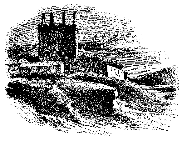
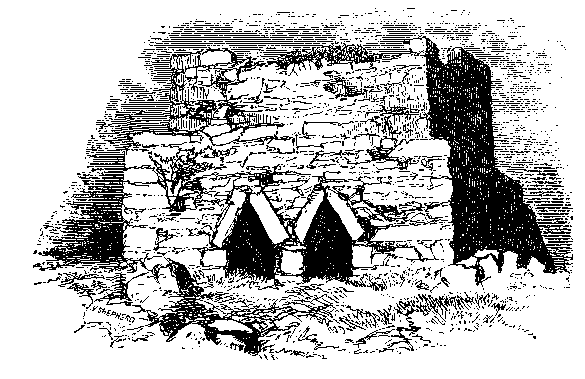
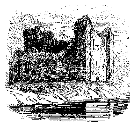
This ancient fortified dwelling of the De Burgos, pictured by the headpiece to this chapter, is known in the annals by the name of the townland of Baile Locha Measca, in which it is placed. Upon a massive decorated chimney-breast adjoining one of the mullioned windows is the following inscription: Thomas Bourke * THS * 1618 * Eilis Butler who, no doubt, occupied, and probably restored, this structure. It is said to have been built by one of the "English barons" in I238; and we know that in 1338, when Edmond De Burgo, the ill-fated son of the Earl of Ulster, was abducted from the Friars' House at Baile 'n Roba on Low Sunday, the 19th of April, " he was that night carried to Loch Measca Castle," which then probably belonged to Sir William Burke, of the lochtar or Mayo branch of that great family.
The next night he spent in Baile 'n Deonach Castle near Petersburgh, at the southern or lower end of the lake; and on the third he was murdered at an island in that arm of the lake, since known as " The Earl's Island." His sister and heir married Lionel, Duke of Clarence. In 1412 Brian O'Conor destroyed the castle of Baile Locha Measca by fire; and in 1416, when another Edmond Burke plundered the territory of Mac Feorais round the southern end of the lake, he took Bermingham himself prisoner, and confined him in this castle.
Passing over the little stream that now divides Inis Mean (no longer an island, but a peninsula) from the mainland, we approach a charming group of ruins, standing by the water's edge, surrounded by well-grown timber, and consisting of the outer castellated gateway of an abbey, and beyond it one of the most beautiful churches in Ireland. Before, however, we enter the sacred precincts, or proceed to examine the ruins of Christian times, let us look back upon the early history of this locality. Across this and the neighbouring island to the west, both of which were probably always accessible in summer time, the Fir Bolg pursued the Tuatha De Danann, and slew the sons of Cailchu upon the lake shore, where their stone circle still remains, as already shown at page 125. It is said Eoghan Beil, King of Connacht, had a " placea " here in the sixth century, from which circumstance the western island is to this day called Inis Eoghain, or Inishowen.
O'Donovan, labouring under the impression that this stone circle, which is evidently monumental, might have been the habitation of the old king, says in one of his letters, written in I838, " The remains of this palace puzzles me very much, though it is not very unlike Dun na Sciath at Loch Eanainn, now Ennell, in Westmeath." There can, however, be no doubt that it is one of the Moytura monuments. It is equally certain that the foundations of the ancient caher, or stone fort, of Eoghan Beil, stood upon the site of the abbey, and a considerable portion of its circle may yet be traced beyond its western end.
From the Book of Lecan Colgan gives a translation of the following
saintly legend, which possibly refers to the end of the fifth century:
" St. Cormac came first to the palace of Eugenius, surnamed Bell, son
of Cellach, King of Connacht, who at that time dwelt in a certain
fort, called afterwards from his name Dun Eoghain, lying in a certain
lake in West Connacht, which is commonly called Loch Measca. But the
servant of God was not received with that honour due to him, nor with
the offices of humanity. Wherefore, the saint, with a menacing and
true prophecy, foretold what he had foreseen by inspiration would
happen to that residence. For he predicted that that fort would not be
hereafter the seat of kings, but that a domicile of the servants of
Christ, and of monks, was to be erected in its place. The truth of
this prophecy has been proved by the event; for on that island,
commonly called Inis Meadhoin, in
 which the vestiges of that fort, afterwards level with the ground, are
seen, a monastery was erected, which from that time remained the
habitation of devoted servants.
which the vestiges of that fort, afterwards level with the ground, are
seen, a monastery was erected, which from that time remained the
habitation of devoted servants.
The next notice of Inis Meadhoin, Inis Mean, or the middle island, which we find is in the Annals of the Four Masters under A.D. I223, " Mael Íosa, the son of Toirdelbach O Conchubair, prior of Inishmain, died." This ecclesiastic was the eldest of the three legitimate sons of Toirdelbach M6r; and it appears that he embraced a religious life in his youth, and left his younger brothers to contend with each other for the sovereignty of Connacht and the crown of Ireland.
When, by whom, or for what order this abbey was
erected, neither history nor tradition gives the slightest
clue; but it was probably built between the twelfth and fourteenth
centuries, and it very likely occupies the site of the original church
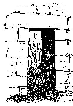
of St. Cormac, and the small square-headed doorway of which is in all
probability that by which the nave of the church was entered from
 the northern side, although it may have been carried there from its original
locality in the west gable of the saint's Daimhliag. The doorway, on page 145, is quite incongruous in either period or
architecture with the noble, highly-decorated structure in which it is
placed. There is no arch above it. Whoever built Inis Meán exhibited great
taste, as well as skill, and, possibly in pious remembrance of the prophecy
of St. Cormac, preserved this portion of his church, which was very likely
all that remained of it when the more modern
building was commenced. The
entire length of th~s great church is sixty-two feet, the breadth of the
nave is twenty-one and a half feet, the chancel is twenty feet by fifteen.
Its arch no longer exists; but, the grand cluster of pillars that still
remain upon the southern side, show that it must have been of beauty
and vast
the northern side, although it may have been carried there from its original
locality in the west gable of the saint's Daimhliag. The doorway, on page 145, is quite incongruous in either period or
architecture with the noble, highly-decorated structure in which it is
placed. There is no arch above it. Whoever built Inis Meán exhibited great
taste, as well as skill, and, possibly in pious remembrance of the prophecy
of St. Cormac, preserved this portion of his church, which was very likely
all that remained of it when the more modern
building was commenced. The
entire length of th~s great church is sixty-two feet, the breadth of the
nave is twenty-one and a half feet, the chancel is twenty feet by fifteen.
Its arch no longer exists; but, the grand cluster of pillars that still
remain upon the southern side, show that it must have been of beauty
and vast
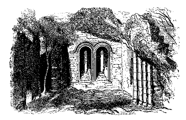
 size, as seen by illustration, page 146.
Fortunately that great Irish
church preserver, the Hedera Hibernica, has long since thrown its arms
around this beauteous ruin or a single stone of Inishmain Abbey would
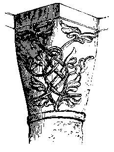
no longer stand upon another. The capitals of these pillars are
decorated with floral embellishments such as exhibited above, which
somewhat resembles that of Cong and Athenry, with which it was
probably coeval. Upon each side of the narrowed chancel there is a
square structure, sixteen feet by twelve and a half, apparently more
for domestic than ecclesiastical uses. The east window consists of two
narrow circular-headed lights,
the outer mouldings both upon the inside and the outside of which
terminate in well-carved grotesque figures; the square doorway on the
northem side; and a breach into one of the side structures, previously
alluded to, ~rP W~oll ch~wn in the fore~oin~ illustration. If this was
indeed an abbey, it probably belonged to the Augustinians, and was
dependent on that of Cong.
size, as seen by illustration, page 146.
Fortunately that great Irish
church preserver, the Hedera Hibernica, has long since thrown its arms
around this beauteous ruin or a single stone of Inishmain Abbey would
no longer stand upon another. The capitals of these pillars are
decorated with floral embellishments such as exhibited above, which
somewhat resembles that of Cong and Athenry, with which it was
probably coeval. Upon each side of the narrowed chancel there is a
square structure, sixteen feet by twelve and a half, apparently more
for domestic than ecclesiastical uses. The east window consists of two
narrow circular-headed lights,
the outer mouldings both upon the inside and the outside of which
terminate in well-carved grotesque figures; the square doorway on the
northem side; and a breach into one of the side structures, previously
alluded to, ~rP W~oll ch~wn in the fore~oin~ illustration. If this was
indeed an abbey, it probably belonged to the Augustinians, and was
dependent on that of Cong.
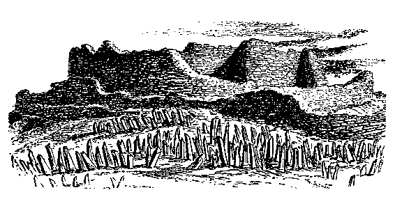
Among the rocks, a little to the west of the ecclesiastical enclosure, there still exist the remains of an ancient circular fort, the walls of which, although frequently repaired, as it is used occasionally for a sheep pen, are so characteristic of the ancient mode of building, and so like those seen in similar structures in Aran, that the above sketch is inserted. It was probably one of the outworks of King Eoghan's fortress. If the intermediate masonry were removed, these long upright stones would present what is termed a Druidical circle.
Passing westwards from Inis Mean church by the
stone enclosure figured above, the author, in I866, discovered, among
the limestone rocks that slope towards the lake, a very curious
structure, of which the illustration on this page is a graphic
representation. It is a square unmortared building, twelve and a half
feet high and
 fifteen feet wide,
with a set-off seven and a half feet from the ground; and, with the
exception of the crypts on the west face, as shown in the cut, is
perfectly solid and formed of undressed stone.
fifteen feet wide,
with a set-off seven and a half feet from the ground; and, with the
exception of the crypts on the west face, as shown in the cut, is
perfectly solid and formed of undressed stone.
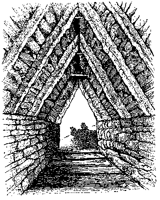
These crypts are certainly the most remarkable and inexplicable
structures that have yet been discovered in Ireland. At top they are
formed somewhat like the roof of a high-pitched Gothic church, with
long stone ribs or rafters abutting upon a low side wall, and meeting
each other at top, as shown in the accompanying engravings. The
intervals between these sloping stones,
some of which are four feet long, are filled up with layers of stone
laid horizontally. The illustration figured on this page, taken from
the outside of the northern crypt, gives a fair representation of this
roofing, above and around which the entire structure seems to be a
 solid mass of stone work. The flboring is also composed of narrow
stone joists placed a few inches apart, so that air can come up
between them, and the partition between the crypts is so thin, that,
although not pervious to light, conversation can be kept up between
them. Each is on an average five feet high throughout, and about three
wide, there are five stone ribs or rafters in the roof of the south,
and seven in that of the north crypt; both outer jambs are slightly
revealed, and the division between
them does not measure quite two feet. The masonry of the outer wall
strongly resembles that of some of our most ancient churches.
solid mass of stone work. The flboring is also composed of narrow
stone joists placed a few inches apart, so that air can come up
between them, and the partition between the crypts is so thin, that,
although not pervious to light, conversation can be kept up between
them. Each is on an average five feet high throughout, and about three
wide, there are five stone ribs or rafters in the roof of the south,
and seven in that of the north crypt; both outer jambs are slightly
revealed, and the division between
them does not measure quite two feet. The masonry of the outer wall
strongly resembles that of some of our most ancient churches.
There is no history and there are no legends attaching to this building, and no person in the neighbourhood ever heard of its existence until last year, neither has any analogous structure been described in either this or any of the neighbouring countries. Possibly it may have been a prison, or penitentiary, in which some of the refractory brethren of the neighbouring abbey were confined. Of its antiquity there can be no doubt.
Still proceeding westward, and skipping with considerable labour and
fatigue from rock to rock, over the huge limestone masses that
intervene between the two islands, and which are perfectly dry in
summer, we pass over into the island of Eoghan, the son of Bel, now
called Inis Eoghain, to visit the great fort and flagstone circle of
the sons of Caelchu (of which the drawing and description have been
given at page I25), and again to rest, while enjoying the lovely
prospect of Loch Measca and the Partrai range, from where the river of
Loch na Fuatha enters at the foot of Cill Bnde wood upon the south
along by the slopes of Tuar mhic Eide round to its Loch Ceara end,
where the view brings within our ken the last object which shall
engage our attention at this end of Loch Measca--the small, and
partially artificial island, almost entirely occupied with Caisledn na
Caillighe, or " the Hag's Castle." This ancient stone fortress may
certainly be regarded as the earliest castle in Ireland, for there is
historical notice of its existence anterior to the Anglo-Norman
Conquest, and it truly resembles, as O Donovan stated many years ago,
a " Cyclopean caher
with cement." The island itself is, partially at least, artificial;
and this great circular enclosure, which is ninety feet in diameter,
and nearly thirty feet high, occupies almost the entire of it, as
shown by the accompanying illustration from a drawing by Master Wilde.
The walls are upwards of eight feet thick at top, and
 slope outwards towards the bottom. There is no doorway at present
existing, but it probably occupied the eastem face, opposite Creagh,
which portion is now quite dilapidated. It is quite impossible that
this outer structure could ever have been roofed; but within there is
a small beehive-like edifice, which, no doubt, served somewhat the
same purpose as that in the enclosure of Acha na n-Iubhar Castle on
Loch Coirib, described at page I69. It is about ten and a half feet in
diameter and twelve feet high, and has several joist holes about five
and a half feet from the ground, and also two large loopholes near the
top.
slope outwards towards the bottom. There is no doorway at present
existing, but it probably occupied the eastem face, opposite Creagh,
which portion is now quite dilapidated. It is quite impossible that
this outer structure could ever have been roofed; but within there is
a small beehive-like edifice, which, no doubt, served somewhat the
same purpose as that in the enclosure of Acha na n-Iubhar Castle on
Loch Coirib, described at page I69. It is about ten and a half feet in
diameter and twelve feet high, and has several joist holes about five
and a half feet from the ground, and also two large loopholes near the
top.
In 1195 Cathal Mac Diarmada O Conchubhair, advancing into Connacht, and plundering as he went, brought the spoil to Caislean na Caillighe, whence he proceeded to commit great ravages on all sides. Again, in I586, Sir Richard Bingham, Governor of Connacht attacked this Castle, which, say the Annalists, " was the strongest fortress in Connacht." It is still well worthy of careful investigation.
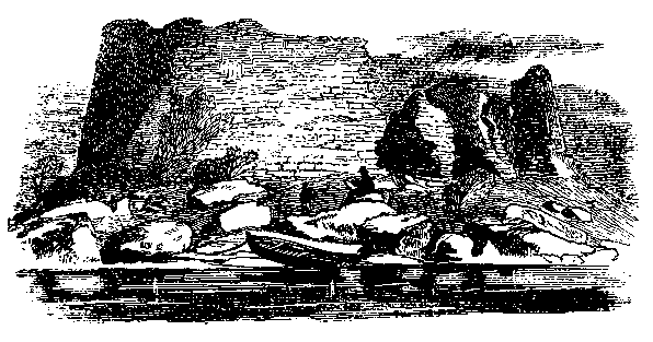
Opposite Inis Eoghain is Daimh Inis upon which there are some ancient remains. In various directions along the Loch Measca road, and through the surrounding fields, may be seen numerous excavations, like old sand quarries, which resemble modern rifle pits, and may be as old as the days of the Fir Bolg and Tuatha De Danann.
Passing round by the lower margin of Loch Measca, along the south of the natural wood of Baile Ul Chadhain, in which there are the remains of another castle by the water's side, we re-enter Galway county by the barony and parish of Ross, and reach the beautiful demesne of Ross Hill, formerly the property of the Berminghams, and then of the Clemences, and later of Sir B. L. Guinness. Near the lake's edge stands the ruin of the very ancient church of Teampull Breanainn, a portion of which may be coeval with that at Inis a' Ghaill. There is a square- headed doorway, with remarkably sloping jambs in its western gable, and a few feet within the church is a dividing wall similar to that at Cill Fhursa, described at page 46. This little church, which is styled on the Ordnance map an abbey, is now sixty-nine feet long by twenty-one wide outside; but a portion of its eastern end, as well as its western bell turret, is comparatively modern. A scarcely legible, and not very ancient inscription, can be traced upon the sill of the sacristy window.
We are now in the district called Joyce Country, which includes the entire parish of Ross, that part of the parish of Cong which lies in the county of Galway, and those portions of Ballinchalla and Ballovey to the west of Loch Measca, and extends from this point through the valley of Mam to the Killeries. O'Flaherty thus writes of it: " The half barony of Rosse, commonly called Joyce Country, from a Welch family of Yoes, Joas, or Shoyes, which held that land from the O'Flaherties (formerly part of Partry-an-tslevy, which extended from St. Patrick's Hill in the Owles to Lough Orbsen), hath the barony of Ballynahinsy, Koelshaly Roe [The Killeries], and the Owles on the west of it; and by a high ridge of mountaines called Formna-mor, is divided on the north from the same Owles. From that mountain, Bruin River falling into Loch Measg, separates Partry mountains, in the barony of Kera, from Kilbridy townland, the north side of Loch Measg [where there] is a chapell and well dedicated to St. Brigid. There is on the south of it an arm of Lough Measg, which shoots into the country westward about four miles to Glenntresky [Glantrague]. On the west of Kilbridy townland is Lough-na-foihy Lake, out of which the river of Gairge comes into that arme of Lough Measg," within which is the Earl's Island.
These Shoeys, or Joyces, were a Welsh colony, who settled here under the O Flahertys in the thirteenth century; but, although the name is still common, the tribe has nearly died out. They were men of large stature, and generally of fair complexion--the last memorable man of the name in this region was Sedn a' Bhdinin, "John of the white Jacket," or big Jack Joyce, who formerly lived at lomaire an Llonain, " the ridge of Leenane." Westwards of Ross Hill, on the lake shore, is the ruin of Baile 'n Deonach Castle, beside Petersburg, the residence of the Joyce Country Lynches.
Along the slopes of Binn Shleibhe from the fort of Cathair Gall,
over the ridge of Fairche, now called Clonbur, down by the tower of
Ard na Gaoithe, " the
 windy height," to Coirib shore we meet with several ancient remains.
Taking leave of the battle field of Moytura and its monuments, we offer, in condusion, the accompanying illustration of Dun Aengusa in Aran Mor, the last great stronghold of the Fir Bolg race, as it presented in I847, and which will serve to explain the character and structure of those Moytura cathairs and duns, of which only the vestiges now remain.
Again taking our western course up the lake from the point midway between the open of Cong river and Inis a' Ghaill, where we deviated, as stated at page sg, we find ourselves within view of some of the best scenery in our route. On our right is Ashford, the tower of Ard na Gaoithe, the heights of Ardan, and farther westwards the plantations of Tuaim n-Eidhneain, creeping up the bold sides of Binn Shleibhe--here rising to a height of one thousand three hundred and seventy feet--flecked with grey and brown from the mixture of rock, bog, and heather, but having its sombre hue turned into azure as the mists are lifted from its face, and reveal the great carn on its summit. From thence, it is said--as has been related of a hundred other places--that a hag or cailleach--for we suppose there were no cailms in these days--pelted another witch, who occupied the top of Carn Sm Finn on our left, where a similar stone heap, at a height of one thousand and nine feet over the sea level, on the southern shore of the loch, raises its bulky form in the parish of Cill Cuimm. This great tumulus, which is about twenty-four feet high, and three hundred and twenty-four feet in circumference, and evidently monumental, can be seen from a great distance all round.
The long line of cormorants that sentinel the great shoal to the north-west of Inis a' Ghaill dip their tails in the water at our approach, and clouds of wild ducks, curlews, and gulls rise on the wing. The peninsulas jut out from the land, the islands and rocks accumulate, and the lake narrows, as we pass into the strait between Dubhros and Ceann a' Bhain; and the Joyce Country and Conamara mountains, on either hand, rise up from the water's edge. On our left is the chapel of Glann - in the district called Ceapach na Idire bdine, and still nearer the lake margin is Coire Riabhach, the planting upon which is beginning to give a civilized look to the brown bogs along the water's edge.
We are now passing between the parishes of Cunga and Cill Cuimm; and in the latter, opposite this point, the Dumhachta river enters the lake to the east of the peninsula of Dubhros, and in the valley through which it flows may be seen St. Mary's, and beside it St. Feich;n's well, or Tobar Fheichtn, where his celebrated altar-stone was preserved until it was removed to Cloigeann. See page 158.
Passing Inis Fhlannáin, we are again in an inland sea, but not landlocked, as those who sail upon it have frequently experienced; for, while it is calm as a fishpond one moment, in another it is lashed into wave and foam as a squall, which had accumulated upon the upper lake, rushes out suddenly through the gap of Dún, and expends its fury upon the eastern sheet of water.
Steering through the narrow intricate passage under the wooded promontory of Cnoc a' Duin, we leave Loch Coirib and the scenery of Mayo behind us, and pass into another region, grander, wilder, and more romantic; the mountains which we had been admiring from a distance now rise up almost perpendicularly around us; the green slopes and sienna-tinted hills change into grey abrupt bare rocks, glowing with ever-varying hues of purple and opal, as the light flickers on the bold sides of Leac Aimhrei, that stands up in an inaccessible pile one thousand three hundred and seven feet high on our left, or brightens up both sides of the great wall of hills that margin the calm lonely valley of Mam, which stretches into the western distance with the Twelve Pins on its southern aspect. But immediately around us the adage is reversed; for contiguity " lends enchantment to the view," and an entirely new condition of nature surrounds us--a placid lake, untenanted by islands, save one lone rock near its northern shore, on which stands in bold relief the picturesque Castle of the Hen--Caisledn na Circe --justly considered to be the oldest fortress of its kind in Ireland, as it is undoubtedly one of the best built.
On our right is the missionary settlement of " Castle Kirk," with its pretty church, glebe, schoolhouse, and mansion; and in the distance, where the great waters of the Mam valley are " mingled in peace," is seen the hotel.
Behind the rock that shelters the church and glebe from the north, St. Feichm's, sometimes called St. Eanna's Well, pours its limpid spring into a rock basin, set in greenest moss, draped with ferns, festooned with ivy, and overhung with red-berried rowan tree, gnarled oak, and dark-leaved holly--the remains of the great mountain woods that once overspread all this region. A curious superstitious practice once attached to this lone retreat; sheltered from the rude blasts of the outer world lay an ovalshaped flagstone called Leac Fheicht'n, " St. Fechin's stone," probably brought from his well at Dumhachta, and which was the " touchstone " and the terror to all evil doers for miles around; for whoever was accused or suspected of a crime was either " dared to the Leac Feichm,'' or voluntarily underwent the ordeal of turning the flag, with certain rites and incantations not now necessary to describe.
Along the valley on the northern shore, in the townland of Drom Snaimh, the ridge or " back of the swimmingford," there is a fort and artificial cave similar to those upon the plain of Moytura, which persons interested in such matters should visit.
Before us on the south-west, on a rock not quite half an acre in extent, with the bold outline of Leac Aimhrei in the background, stands the picturesque ruin figured overleaf, from a sketch made by Mr. Wakeman in I839. This ancient castle, which occupies almost the entire island, originally consisted of a quadrangular keep, forty feet by thirty-eight internally, placed in the direction of the cardinal points, and having square towers at the corners; and upon the south, or entrance face, an oblong additional tower, containing several apartments. It is all built of limestone; the intermediate walls between the towers are of rubble masonry, composed of undressed stones, not arranged in courses, but grouted with fine white mortar; while the towers are constructed with great regularity, and their sawn quoins average fifteen inches long and six square. Unhappily, before this noble historic ruin became the property of Sir B. L. Guinness vandalism reigned in the district, and hundreds of these beautiful quoin stones were removed to erect residences in the neighbourhood. The original entrance appears to have been on the south side, between the middle and south-west towers, the slopes or " battering " sides of which present architectural peculiarities well worth the attention of artists. Scrambling up into this aperture, a small guard-room in the eastern tower, six feet ten inches long, by five feet ten inches wide, and seven feet high with a stone arched roof, called O Conor's chamber may be entered through a circular-arched doorway twenty-six inches wide. On the inner face of this tower at the south-west angle, there is a deeply splayed pointedarched window, seven feet five inches in span internally and a circular-arched light exists in the northern tower, the external angle of which overhangs the bare rock, and IS supported with an uncemented arch and corbelled work, as may be seen in the illustration. There are long narrow lights in the north and west walls of the keep; and in the northern wall, which is forty-five feet eight inches long externally, the garderobe aperture may be seen.
The interior of the keep is now a mass of stones and weeds; but about ten feet from the present floor a series of joist holes show that it was floored, and must have been roofed in whole or in part. Each tower has a winding staircase leading to the top, and also opening into horizontal galleries which lead through the thickness of the wall. All these towers batter at their bases, which are solidand that at the north-east is thirteen feet wide. The southwest tower has a remarkable deep recess, but its base slopes more than any of the others, and runs out in an angle towards the lake, where there are the remains of ancient foundations--probably of the landing place. The view which we have given of this castle was taken from the water on the northeast side, and gives the best general idea of the building; but the southem aspect, especially the peculiarity of the entrance through these towers, is well worth illustration and architectural description.
The south-east tower is much dilapidated; but it evidently had an entrance to the small garden platform on the eastern side of the castle, which led by a staircase to the middle tower, that was evidently the chief domestic portion of the building; while probably the keep and northem towers were appropriated to the soldiery and dependents. There is a square apartment in this middle tower with pointed-arched doors; and here we also find one of those speaking holes built through the substance of the wall, like that already described in Eanach Duin Castle, at page 30. The intervening wall between the eastem towers measures twenty-nine feet on the outside.
If well provisioned, and defended with any degree of bravery, this castle must have been impregnable at the time of its erection; and, as the rocks slope abruptly into the water on all sides, it is only accessible in a few places. At the north-east angle its height over the rock is now thirty-five feet. Viewed from any side--from the level water surface, as we pass round the point of Dún; or as glimpses of it are caught as we approach it from the Killery road; or when it first bursts upon our view, as we commence the descent of the mountain road leading from Corr na Móna to Mám: or as we look down upon it from " the yellow pass " upon the Galway road--it presents, with all its mountain surroundings and water settings, the most picturesque ruin in the country.
The legends respecting its name, origin, and history, are as numerous as they are fabulous-- how it was built in a night by a cock and hen--how it was defended by the Lady O Flaherty after O Flaherty an Coileach, or the Cock, had been slain, whence the heroine derived the soubriquet of the Hen, or an Chearc--again, how it was built by a chieftain named Darka--and how the celebrated Grdine Uaille, after she had abducted the heir of Howth, carried him thither, etc., etc.; some of which fables the guides and boatmen will no doubt relate to the tourist. Antiquaries have, however, always regarded it as one of the oldest mortared castles in Ireland. From the notices of it given in the Annals of the Four Masters, it would appear to have been erected by the sons of Roderick O Conor, assisted by the son of William Fitz-Adelm, the original De Burgo; and the tradition among the oldest inhabitants to this day is, that it was built by " O Conchubhair, King of Connacht." As already stated at page 38, the Lord Justice, in r22S, caused Aodh O Flaherty to deliver up Kirk Island~ and the boats of Loch Coirib, to Aodh O Conor, King of Connacht; and in I233, " Felim, son of Cathal Crov Derg, assumed the govemment of Connacht, and demolished the castles which had been erected by the power of the sons of Roderick O Conor, and the son of William Burke, namely, the Castle of Bungalvy, Castle Kirk," and that on the Hag's Island, already described.
In 1256, Walter De Burgo, first Earl of Ulster, marched against Roderick O'Flaherty, plundered territories of Gno Mor and Gno Beag, and took possession of the lake, its islands, and castles. " These he fortified, and by that means considerably increased the power of the English in Connacht; " so that, although it might have been built by Irish chieftains, it would appear to have been within the power of the English settlers in the thirteenth century. Roderick O Flaherty, writing in I684, says, " Kirke Isle, or the Hen's Island~ Iyes in that part of Lough Orbsen which is within Ross half barony and had a castell till broken in Cromwell's time." It is in the parish of Cong, which divides the lake in this place from that of Ross, which latter tums round by the bridge of Mam, and occupies the westem shore of the lake, to a point exactly opposite the Hen's Castle.
We now pass up to Bun Bonain, where the confluence of the Faill Mor and Beal a' na breac rivers, already described, enters the lake; and, as we row by the sedgy margin of the latter stream, we have before us the hotel and bridge of Mam, both erected by Alexander Nimmo --a man whose memory should be revered in the West; as, with the assistance of Dick Martin, he was the first to open up Conamara; and whose well-engineered and admirably constructed roads, and valuable reports upon the capabilities and resources of this great district can never be sufficiently appreciated.
The hotel was built by Nimmo as a residence and pay office, at the time of the erection of the bridge. It is an attractive resting place for tourists, as, independent of the beauty of the scenery, and the interest of the neighbourhood, and its admirable trout and pike fishing, it is within four miles of the main road between Gaillimh and An Clochan (Clifden) upon which several conveyances ply daily.
Passing up the road by the bridge and waterfall of Tlr na gCoill; winding over An Beama Bul, with its bold mountain ridges on either hand, and proceeding down along the wooded lakes, we leave theJoyce Country and the parish of Ross, and approach Conamara proper, or the barony of Ballynahinch; but again, tuming eastward at the cross roads, we once more enter upon the district of Iar-Chonnacht by the extensive parish of CILL CUIMIN, which, stretching across from this point for many miles both east and west, occupies the space between Cill Aithtun parish and that of Magh Ruis, and extends from Loch Coirib to the sea. To the east is the post-office of Bun na Coille; and as we approach Uachtar Ard, the island of Inis Sean Bo, is on our left hand.